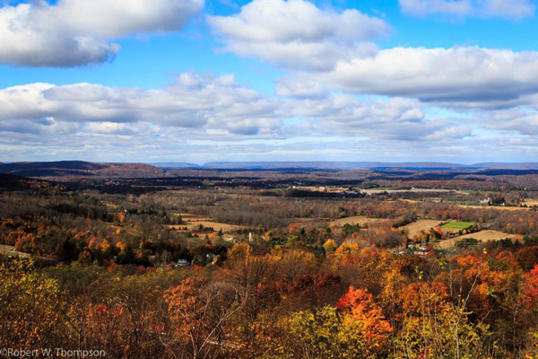
Traveling along Interstate 80 at high speed, it takes less than an hour to traverse the scenic terrain of Northwest New Jersey, a landscape that took more than a billion years to sculpt. If you let it, this road can be an instructive trail leading from a prehistoric glacial swamp, up across a glacial moraine along the distinctive geologic face of the highlands, and through the beginnings of the vast valley and ridge province, before the road continues on its way across the continental United States. Unobstructed by signs and buildings (aside from the sound barriers), the corridor has things to offer beyond the headaches and always-dangerous flow of traffic. So enjoy your next ride on the Christopher Columbus Highway with a new perspective!
Although the continent-size sections of the Earth’s crust—called tectonic plates—usually move just inches each year, they exert tremendous pressure on each other that over millions of years causes them to overlap, fold, and fracture. Cracks develop in the Earth’s crust, known as faults, and the sections on either side of a fault may rise, drop, or slide sideways, sometimes on an epic scale.
It happened right here, as I-80 heads west out of Wayne, through a few flat miles of relatively natural surroundings beyond the Passaic River. More than 200 million years ago, the land between the Ramapo Fault, near Parsippany-Troy Hills, and another fault west of Paterson, began to drop, creating the Newark Basin, a valley that extends from the Hudson River southwest, almost to Gettysburg, PA.
The walls of the fault eroded, slowly filling sections of the basin with sediments, sometimes as deep as 11,000 feet, that lithified ever so slowly into layers of conglomerate rock (gravel and pebbles trapped within a stony matrix) and sandstone. As the Earth’s plates continued their interplay, these layers comprising the basin’s bottom were tilted slightly upward, and as they eroded, the harder, more durable rock remained as the area’s ridges, while the softer sediments and sandstone filled the valleys. Thus the canvas was created for geology’s most “recent” rendering by the glaciers.
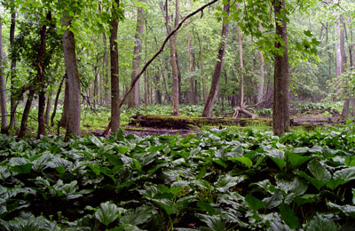
During at least three climatic cooling-warming cycles, the first of which occurred 2½ million years ago, huge sheets of ice thousands of feet thick spread southward under their own weight before receding back northward during warmer periods. The last glacier—the Wisconsinan—affected our area between 75,000 to about 12,000 years ago, eventually retreating and leaving its meltwater collected in a huge depression formed by its unfathomable weight. Although the glacial Lake Passaic once covered much of Morris, Essex and Passaic Counties, only marshy wetlands remain as a reminder of its existence. West of the Passaic River, Interstate 80 skirts the boggy wetlands called Passaic Meadows, which 14,000 years ago were covered with more than 200 feet of water! Great Piece Meadows and Troy Meadows, two small sections of Passaic Meadows covering about 10,000 acres, struggle to retain their wetland characters. Despite human alteration of their hydrologies and drastic encroachment by development, interesting plants and wildlife still abound in preserved areas just beyond the lines of cattails along the highway. It even smells like a swamp!
After the interstate crosses the Ramapo Fault near Parsippany, leaving the low rolling Morris plains of the Piedmont province behind, it rises through the knolls into the Highlands province, characterized by lakes, streams, forests, rocky ridges and mountainous uplands. The oldest rocks in the state—gneiss (pronounced “nice”)—are in the Highlands, dated at more than a billion years old.
About 480 million years ago, northwest New Jersey was covered by a warm, shallow, sandy-bottom sea, brimming with algae and ancestral snails. The calcareous shells of a myriad of micro-organisms built up over millions of years into layers which became limestone and dolostone. Tectonic pressures pushed mountains as high as today’s Rockies up through the sea forming the ancestral Appalachians, roughly centered over New Jersey’s present coastline. For millions of years, as the first land plants developed, the westward flowing streams carried eroded gravel and sand off the mountains, wearing them down and covering the sea bottom with new horizontal layers that would eventually turn into sandstone and conglomerate rock.
Then about 460 million years ago, the continental shelf dropped, and the once-shallow sea became hundreds of feet deep. For the next twelve million years mud sediments poured into the basin, building up layers 12,000 feet thick that eventually became shale, and then slate.
Then, one more time, about 370 million years ago, when life on Earth consisted mainly of primitive plants, fish, and insects, the region experienced another period of mountain-building, followed by erosion, deposition, and lithification. New horizontal rock beds were formed, only to be subjected to the same cycle yet again, one which finally gave us the beginnings of today’s landscape.
After millions of years of erosion, only the ancestral mountain’s uptilted roots and its debris remain, the oldest layers to the east, youngest to the west, making the Kittatinny Ridge along the Delaware River the youngest of all. As always, erosion left the durable layers as mountains by carving away the softer or soluble rock of the valleys. These layers are clearly visible in the strata of the Delaware Water Gap and appear as large bands on geologic maps.
The battered geologic ruins of the nearly obliterated ancestral Appalachian Mountain, which itself had been formed from the ruins of earlier massifs, now lie pulverized and scattered before us.
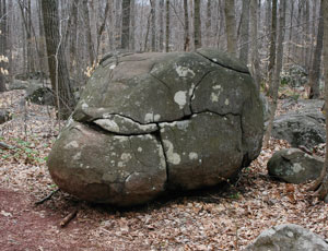
The glaciers carved a final face into the New Jersey Highlands landscape, moving down from Canada at least three times, their massive weight wearing down old ridges and scouring out deep valleys, bulldozing boulders and rocks ahead of them while grinding others into pebbles, gravel, sand, and finer sediments. Then, as they receded, glacial meltwater cut new valleys, widened old ones, and washed out vast amounts of debris orphaned from its original rock layers miles northward. Some of the rubble left behind filled the valley floors or was deposited as hills and terraces; some of it remained as boulders called glacial erratics. Large sinuous rows of rocky debris, called moraines—mark the glaciers’ farthest southerly advance.
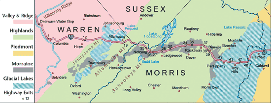
From Exit 37 in Rockaway, Interstate 80 rides westward for about eleven miles atop the Wisconsinan moraine, a natural causeway over the Highlands’ swales and ridges that extend to the northeast and southwest. The ice, once thousands of feet thick, has left us with the glacial Lake Hopatcong to the north, and Budd Lake, another glacial relic to the southwest. Although thousands of years of decaying plant debris have slowly turned sections of Budd Lake into bog, groundwater seepage continues to fill the shallow impoundment, which remains New Jersey’s largest natural body of water and the source of the South Branch of the Raritan River. An abundance of aquifers throughout the Highlands are the most important sources of water in New Jersey.
Near the top of Schooley’s Mountain, after Exit 26, the interstate leaves the moraine and descends into the Musconetcong Valley. The Musconetcong River has spent many thousands of years cutting down through the slate and limestone-type rock to form its valley between the ridges of Schooley’s and Allamuchy Mountains which consist mainly of billion-year-old gneiss, much more resistant to erosion.
After crossing Allamuchy Mountain, I-80 descends to a flat wetland—the Great Meadows—part of the Valley and Ridge province, a geological corduroy characterized by long ridges and valleys running parallel, north-to-south. The valley is part of the more extensive Great Valley that includes the Champlain, Mohawk, Hudson, Kittatinny, Lehigh, Cumberland, Shenandoah, and Tennessee Valleys.
The Great Meadows is a vestige of ancient glacial Lake Pequest. Thousands of years ago wildlife flourished along the marshy edges of the lake, which would have covered the interstate with at least fifty feet of water. Nine-foot long giant beavers swam, and mastodons grazed here as evidenced by the numerous bones recovered from the marsh over the years. The huge volume of decaying plant life and sediments that accumulated on the primordial lake bottom turned into the rich peat-like soil that supports farm produce and sod growers today.
After following the ancient glacial lake bed for another three miles, I-80 climbs slightly as it passes over the northernmost foot of Jenny Jump Mountain, a small spur of the Highlands that contains rocks as ancient as those of the mountains to the east. Soon this rock layer disappears beneath the sedimentary rocks of the Valley and Ridge, not to be seen again along the interstate for 1700 miles when it reemerges near Cheyenne, Wyoming. Sections of Jenny Jump are still devoid of topsoil, stripped away by the Wisconsinan glacier, which buried the mountain under a thousand feet of ice.
From Jenny Jump , the interstate rolls along over a valley of slate and limestone and some areas covered by gravels washed out by the receding glaciers. The rock layers between the base of Allamuchy Mountain and the Kittatinny Ridge—the easternmost major ridge of the province which extends westward into Pennsylvania—have worn down faster than the more durable sandstones and conglomerate rocks of the Kittatinny Ridge and the gneiss of the Highlands to the east. The creeks and streams follow the direction of the softer valleys, sculpting them deeper and deeper. Yet the Delaware River seems to have existed at an earlier time, allowing it to cut crosswise through the layers of rock as they were slowly pushed upward by tectonic forces. The Delaware Water Gap is one such example of that action.
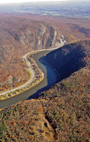
As I-80 swings northward beyond Columbia, the huge rift in the Kittatinny Ridge presents an awesome view, striking in its banded layers of sandstone and conglomerate rock as the Delaware River winds through it. The exact age of the Delaware Water Gap and how it formed remain unanswered questions. Possibly tectonic folding caused a crack through which water began to flow and erode the ridge. Or perhaps the headwaters of a south-flowing stream cut progressively farther northward until it bisected the Kittatinny Ridge. Maybe it was a combination of both processes. But whenever and by whatever means the Gap was formed, it was most likely in place long before the glaciers arrived, although striations cut into the walls of the Gap indicate that glacial action probably contributed later in its development.
So, the mountains of the Water Gap contain the remains of horizontal layers of eroded material that turned into rock and were then tilted upward by the pressures of colliding continental plates to become the westerly side of a huge mountain-sized wrinkle. The wrinkle has eroded down to what it is today: mostly picturesque layers of lithified sandstone and conglomerate rock. Looking at the Gap from the human perception of time, it appears to be a complete work. But geological processes are still changing the Gap, drop by drop, pebble by pebble, as the river continues to flow through it.
With the passing of the Wisconsinan glacier, the area became a warming tundra, a treeless permafrost in which the first grasses slowly began to thrive, gradually evolving into a somewhat marshy area in which coniferous forests took hold. Large mammals spread into the area followed by the first humans—paleo-Indians—possibly as early as 10,000 years ago. Over the centuries, their paths developed into byways for the European settlers, which in turn evolved into our roads, highways, and superhighways such the one we ride today.