I’m sure I’m not alone in my fascination for bridges. But what accounts for their allure which extends beyond their well-engineered facilitation of travel across inhospitable features of the landscape? As a child I had a recurring nightmare so profoundly unsettling that I still remember it clearly. My family is driving to the shore, traveling south on the Garden State Parkway and climbing up the Driscoll Bridge, where the Raritan River widens to meet Raritan Bay. The almost mile-long bridge is a busy affair, with fifteen lanes of traffic; twenty-one if you count the adjacent lanes of the Route 9 bridge. The Driscoll has a steep arch, so that you cannot see the far side of the bridge while climbing to the crest. In my dream, the bridge does not collapse; it simply fails to deliver me to the expected other shore. Instead, it launches me into a chaos of sky, river, cars, trucks and busses. I am not falling towards the water, I am floating in the air and submerged in the water at the same time. I am engulfed in a sheer confusion of matter; unmoored, lost, and adrift. With nothing to hold on to, I awaken whimpering with mortifying terror.
Except for the memory of that nightmare, I have no lingering fear of bridges. Instead, as structures, they fascinate me. There must be some link between that child’s fear and an adult’s fascination, which for now I will simply accept. Bridges of all types are ubiquitous across the landscape, from the simple culvert to the monumental architectural sculpture of the Governor Mario Cuomo Bridge. Bridges mostly connect equivalent topographies across a sharp interruption to that landscape, whether a gorge, waterway, road, railroad, or terrain occupied by homes and factories. The Pulaski Skyway, in Jersey City, Kearney and Newark, which opened in 1935, is a combination bridge and elevated roadway. It crosses the Hackensack and Passaic rivers, the Meadowlands and Kearny Point. It is considered functionally obsolete and rated one of the most unreliable roads in the country. Yet its low-slung three and a half miles of black steel latticework — hanging below the road deck when the Skyway is over land, rising above the road deck for the river crossing, changing from a deck truss cantilever to a Pratt truss bridge four times — renders the Skyway sleek and impressive.
Bridges can also beguile with their simple beauty. In the Musconetcong Valley there are a slew of old iron truss bridges crossing the river that add immeasurable character to this quaint agricultural landscape. Rivers often mark the boundaries between political entities, and the Musconetcong River is no exception. A little over a mile from where the river empties into the Delaware, crossing the historic Finesville Bridge (c. 1890) on Mt. Joy Road in Holland Township in Hunterdon County brings you to the stone cottage village of Finesville, a State and National Historic District in Warren County’s Pohatcong Township. A dam was recently taken out just upstream from the bridge to improve the ecological values of Musky by removing impediments to fish habitat. Removing dams for environmental reasons has occasionally led to conflicts with history advocates when a dam and former mill pond have been intrinsic to the development of a settlement and contribute to its historic character. Compromises have been made, such as breaching the dam instead of removing it entirely.
Bridge renovations often face similar concerns about desecrating the cultural landscape. Six miles upstream from Finesville is a similar truss bridge (c.1892), connecting the historic Borough of Bloomsbury with Greenwich Township. In 1994 the bridge was widened. But instead of demolishing the original lattice of truss webs, which would no longer be needed for structural support, they were reattached as decorative members. Bridge experts will at once notice the odd proportions of a two-lane road held by a single lane design, but all agree that the preservation of the original members was far more desirable than destroying the bridge’s, and the Borough’s, historical character. A similar compromise was reached in the upgrade of the bridge on Main Street in the Borough of Califon, Hunterdon County. The highly ornate bridge was built as a single lane bridge over the South Branch of the Raritan River in 1887. When the bridge was expanded to two-lanes in 1985, the trusses were retained, but only as ornamental elements.
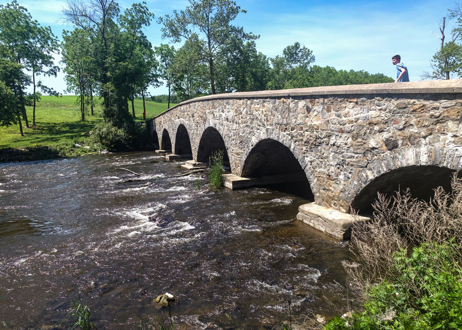
Several more historic truss bridges, with their weathered green patinas, cross the Musconetcong River before the picturesque valley ends as it approaches Hackettstown. The Shoddy Mill Road Bridge, although currently closed, is the oldest (1868) of the Musky bridges and according to a historic bridge expert’s report, “a lovely little bridge of extreme rarity.” One and three quarters of a mile upstream is the two-span stone arch Changewater Road Bridge, built in 1900. This single lane bridge has a pedestrian walkway. Several imposing stone piers on either side of the bridge once held a railroad crossing for the Warren Railroad spur of the Delaware, Lackawanna and Western Railroad. The area is known as Changewater because it is at the confluence of the lower and middle sections of the Musconetcong River.
Three miles upstream is the Point Mountain Road Bridge which was originally built in 1905 and rebuilt in 2019 with a reasonably accurate pony truss style bridge replacement by Hunterdon County. The river on either side of the bridge is a favorite spot for fly fishing. Near the bridge is the parking area for the Musconetcong River Reservation. A short, steep hike from the parking area brings you to an expansive view from Point Mountain of the Musconetcong Valley. It is a hearty climb, but well worth the view.
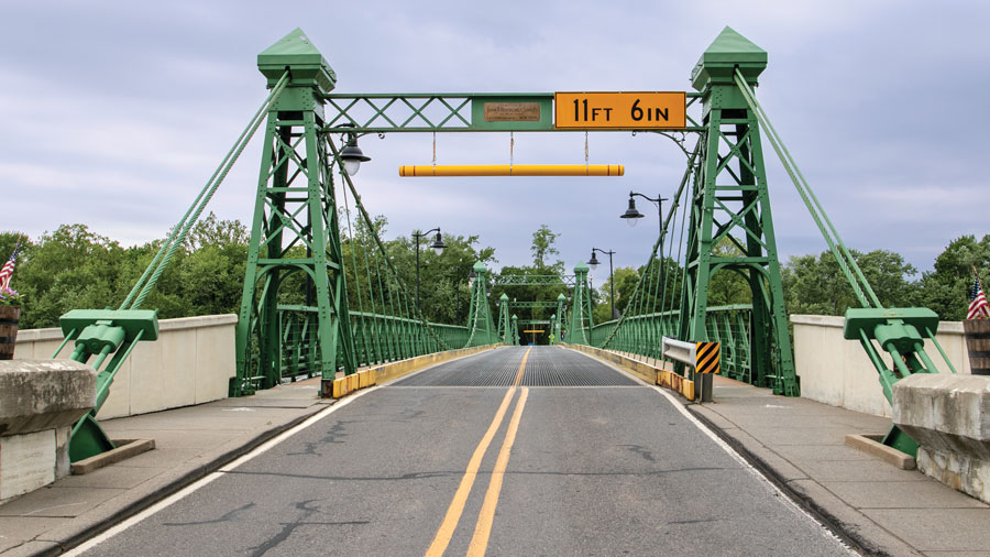
Back on the Delaware River, about a half mile north of where the Musconetcong joins, is one of the more interesting bridges in New Jersey. The Riegelsville Bridge, connecting the Village of Riegelsville in Pohatcong Township, NJ, with Riegelsville, PA, is unusually ornate because it was built in 1904 by the John A. Roebling Sons Company of Trenton. Roebling was famous for manufacturing the suspension cables for the Brooklyn, George Washington and Golden Gate bridges, and other well-known bridges across the country. Although the two-lane bridge’s deck is only 190 yards long, it is elaborately suspended from four towers, with pedestrian walkways on both sides. Perhaps Roebling over stated his design simply to be playful with a small bridge so close to his factory. Owned by the Delaware River Bridge and Tunnel Commission, it was sensitively rehabilitated in 2012, without any corruption of the bridge’s historical integrity.
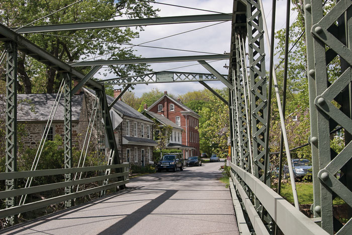
The other two-lane metal bridges that cross the Delaware River north of Trenton, although not as ornamental as at Riegelsville, are charming in their own way, always complementing the allures of the river towns which they serve. Stockton, Lambertville, Frenchtown and Milford all vary in size and bustle, but they all share a common appeal that beckons you to visit, to walk their main Bridge Street, to linger for a bit, to stop in for a bite or a drink. And it is always inviting to walk out over the river on the pedestrian lane.
There are some interesting and imposing stone arch bridges that were part of the Lackawanna Cut-Off, an elevated rail line constructed from 1908 to 1911 across mountainous northwestern New Jersey to provide a straighter, shorter and quicker route from Hoboken to Scranton, PA. There were no road crossings, only bridge overpasses constructed with reinforced concrete. The iconic Delaware River Viaduct crosses the river at Columbia, and an even larger structure four miles east is the Paulins Kill Viaduct, which when completed in 1910, was the largest poured concrete structure in the world. Station Road in Knowlton, just north of the Paulins Kill Valley Trail, travels under the bridge. The line was abandoned in 1972 and both bridges are in disrepair. However, NJ Transit is working to restore passenger service on the Lackawanna Cut-Off, first between Andover and Lake Hopatcong, and eventually across both viaducts, to Scranton.
Also in Knowlton, one and a quarter mile downstream from the Paulins Kill Viaduct, is the lovely, single lane, stone arch, Brugler Road Bridge, built in 1860 and reconstructed in 1931. The bridge is situated on a not untypical bucolic stretch of the Paulins Kill, surrounded by forested hillsides and farms. On the east side of the bridge, the Paulins Kill Valley Trail continues to the north. On the downstream side of the bridge, large limestone boulders are scattered on the shores and in the water. In 2019 an abandoned small-scale hydroelectric plant and dam was removed one half mile downstream, in a joint project of American Rivers, Princeton Hydro and The Nature Conservancy. The rocks were placed in the water as part of the project, to provide the riffles and breaks that trout and shad enjoy. Recently, shad, which was obstructed by the dam, have returned to the Paulins Kill upstream of the dam, for the first time in years.
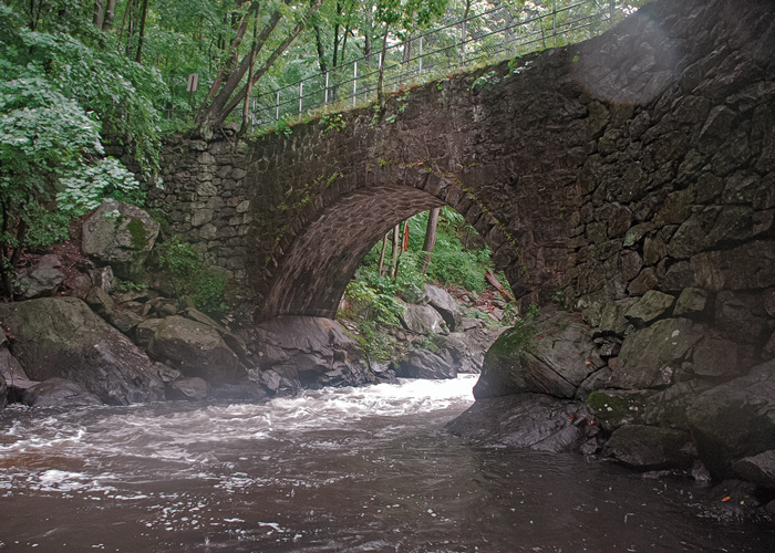
The town where I live, Boonton, has a particularly lovely and historic stone arch bridge. In Boonton’s Grace Lord Park, on the trail that follows the Rockaway River through the succession of falls and cataracts of Boonton Gorge, the trail crosses the river over the Arch Bridge, a hand-crafted stone arch pedestrian bridge, built in 1868. The stone was cut from the Highlands granite outcrop known as Indian Rock, still there, on the far side of the bridge. This area has many remnants of the Boonton Iron Works, which was constructed here in the early part of the 19th century, to take advantage the Morris Canal, just yards away, to bring in coal to fuel the two blast furnaces, and to transport the pig iron and nails that the Iron Works manufactured from the ore supplied by nearby Highlands’ iron mines. The Arch Bridge was constructed for workers to conveniently cross the river and as an aqueduct, to provide fire suppression in times when water in the river was either frozen, or insufficient in late summer. The Town of Boonton received funding from the State Historic Trust to rebuild the Arch Bridge as it is bad need of rehabilitation. Gazing upstream from the bridge, the roaring, falling, white water of the Rockaway is quite a spectacle as it blasts through the Boonton Gorge. It’s easy to understand how the power of falling water operated the Iron Works furnace bellows and the Morris Canal’s inclined plane.
Cross the next bridge when you come to it, but not without considering its story and its style. A bridge’s context and charm can make your passage delightful.