Rising beyond the eastern shore of the Rockaway River, a Passaic River tributary, stands the Tourne, a modest mountain known for its rocky terrain and spectacular New York skyline views. A woodsy retreat dotted with glacial deposits, it overlooks historic country landscapes, long favored by bikers, hikers, naturalists, horse and aviation enthusiasts: a recreational and picturesque oasis in the middle of busy Morris County.
Though a mere mound by Western standards, the Tourne's name is a take-off on the Dutch word for "tower"—said to have been given by early Dutch settlers. Despite its height, just under 900 feet in elevation, the peak somehow manages to fold into much of the surrounding territory. Unless you find your self positioned atop a Boonton hill, or at the far end of a cleared farm field in adjacent Boonton Township, you might not notice the Tourne at all. From Mountain Lakes, which sits right in its shadow, it is all but invisible.
And yet the Tourne and the land surrounding it should be seen, not only for their natural beauty, but for their rich history. Part of the broader Passaic River Valley, the area originally was the province, like so much of northwestern New Jersey, of Lenni Lenape Indians. Some of the property viewed from the top of the Tourne was owned by the famous early American speculator, William Penn. The landowner of the Tourne property itself was also prominent: colonial lawyer David Ogden (1707-1798), who purchased it as part of "The Great Boonton Tract" in 1759. Ogden, a Yale graduate born in Newark, held positions in New Jersey's colonial legal establishment, including the New Jersey Bar and Supreme Court. It was his son, Samuel Ogden (1746-1810) who developed the land by building the original access road to the Tourne in 1767. Now called McCaffrey Lane, this is one of the area's oldest thoroughfares and remains the primary entrance road. An interesting footnote to the Ogden family history is that father and son took opposite sides at the time of the American Revolution. David Ogden was a loyalist, forced to take refuge among British troops in New York during the fighting; Samuel served as colonel of the New Jersey Militia.
Before the Ogden's time, in Indian days, Tourne territory was marked mainly by thickets, and a network of brooks, swamps, and wetlands. But Ogden's road project changed that, providing a path for commerce and development, based on an ample supply of timber, water, plus iron ore in nearby hills. McCaffrey Lane was built as a path for hauling iron. In the 1770s Samuel Ogden founded The Boonton Ironworks, the centerpiece of the local economy for nearly a century, which finally collapsed in 1876.
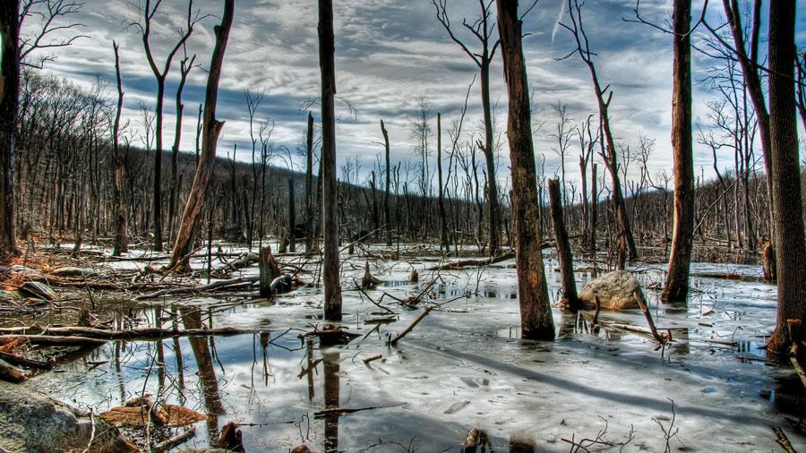
Nearly one hundred years later, the Tourne County Park opened, in 1960. Today, it encompasses 546.9 undeveloped acres for walking, picnics, ball games, playground fun, sledding, cross-country skiing, show shoeing, fishing, and bike or horseback riding (bring your own equine). Its natural features include a broad and colorless swamp, eerily populated by a host of beaver cut and half fallen, decaying trees; a pleasant flat stroll or run to a Mountain Lakes park with views of Birchwood and Crystal Lakes, a woodsy hike to the summit with open outlooks, and a wildflower garden dedicated to native plants.
Forming a hub uniting three towns, Denville, Boonton Township and Mountain Lakes, the Tourne district—the county park and surrounding countryside—can be explored on foot, mountain bike, horseback, or from the window of a car. (The mountain trail is off limits to cars; park and hike or ride from the public lots). There is access parking on the western Denville side off Old Boonton Road and on the Boonton Township side off McCaffrey, which leads into the park from Powerville.
A broad path, "DeCamp Trail," that leads to the top of the Tourne is manageable for most fitness levels and wonderful if undertaken on a cantering horse. (More adventurous bushwackers on foot can choose a steeper and more strenuous route, picking their way up and around glacial outcroppings). On a clear day, the climb's rewards are rolling mountain vistas trailing off into Pennsylvania on the western side (a log bench along the trail invites contemplation) and dramatic thirty-mile New York skyline views from the summit. This vista can be taken in from a pleasant, tree-shaded plateau, with picnic tables, in the company of an impressive free-standing boulder, known as Mouse Cradle Balancing Rock. Said to weigh 54 tons, the rock, a glacial deposit, was wedged at an angle by its namer, Clarence Addington DeCamp, the owner of the property in 1859. Legend has it, he took pity on a mouse who'd made nest in one of the rock's depressions. Not far from Mouse Cradle, comfortably smooth and broad rock outcroppings on the southern side invite sunbathing and lingering. A Tourne community 9-11 tribute site, where for a decade climbers have left momentos and flowers, draws the eye inevitably toward the prominent vacancy on the southern end of the skyline.
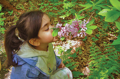
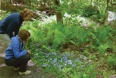
After contemplating distances from the summit, it is a pleasure to descend DeCamp Trail and walk down the road to the Emilie K. Hammond Wildflower Trail, whose small, delicate charms invite close inspection. Fenced against deer, the garden is filled with delicate treasures. Expect its wildflowers to be at their peak in April and May, its ferns and trees from mid-summer through fall. In spring, hundreds of native plants, including trout lilies, virginia blue bells, trilliums, violets, blood root, wild azalea, jack in the pulpit, and bleeding hearts, surround the self guided woodland walk, maintained by the Rockaway Valley Garden Club and named for a local botanist. Many are labeled, except one or two desirable ones that unfortunately have attracted human, not animal, thieves.
The most recent addition to the Park lies across Old Boonton Road from the west entrance. This much smaller and flat property runs near the old the Morris Canal and along the Rockaway River. It is a popular dog walking and meandering spot, with a mowed path that moves the visitor through a peaceful grass field to the water's edge.
Exploring outside the boundaries of Tourne County Park provides further diversion and vistas. On the adjacent Mountain Lake side, architectural interest can be found in one of the country's largest collection of Craftsman-influenced turn-of-the-century homes, hundreds of which are still standing (public parking is provided at several points along the suburban community's main thoroughfare: the Boulevard). These homes can also be seen from wooded trails just below the highest hill of Mountain Lakes, on the Tourne side of Crestview Road.
Venturing into more rural Boonton Township yields activities and sights for families, animal lovers, and aviation buffs. Turning north off McCaffrey Road, through the iron district known as Powerville (the Powerville Hotel, now part of an eldercare facility, still stands opposite the river) and abandoned locks of the historic Morris Canal, Powerville Road leads to the heart of picturesque and historic Rockaway Valley. Its scenic cross roads, known as "Four Corners, " is a gateway to countryside that wraps around the Tourne's northern base. (Public parking at the RFL Fields off Powerville Road provides a good access point).
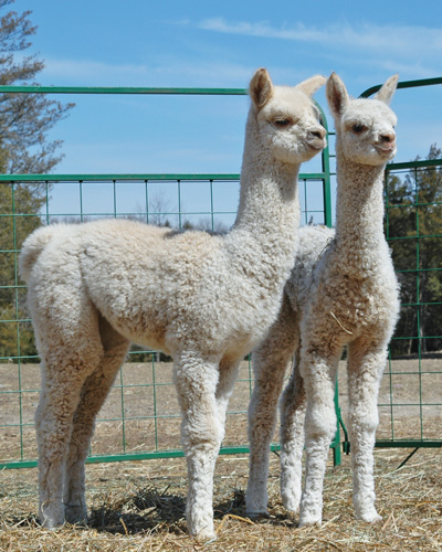
Brookhollow Farm, an alpaca breeding farm owned and operated by the Johanson family (whose Johanson Manufacturing Company stands just down the road), is home to a herd of about 130, which takes pride in a record of championship and nationally recognized herdsires, including a fluffy and sturdy white stunner named "Snowmass Invincible" and his progeny. The farm's alpacas can be seen frolicking under the oversight of their guardian llamas beyond the white fence that surrounds the large property (a small turn-out at the corner of Rockaway Valley and Powerville Roads provides very short-term drive-by parking; Brookhollow's parking is at Johanson Manufacturing). Spring at Brookhollow brings an its annual highlight: alpaca shearing the first Saturday in May (May 5 this year) during which alpacas are led by handlers in a parade from the fields to the barns across the street for their summer cut, with great gentleness and fanfare. "Onlookers are welcome, and they will be intrigued by the rapid change from fuzzy to "bald" when the alpacas are shorn, " notes Nancy Johanson. For the event, an "Alpaca Crossing" street sign is erected. The season is also marked by the arrival of baby animals at the Brookhollow Barnyard, where miniature sheep, donkeys, horses and pygmy goats are among the attractions. One newcomer, a "young yak" named Bruce, has been bottle fed since he arrived last October. Brookhollow birthday parties feature a party barn, and picnics; a tractor pulled wagon takes visitors around the farm. The Shoppe at Brookhollow, occupying an old farmhouse, sells alpaca clothing and accessories.
Across Powerville Road, on the eastern side of Four Corners, border collies can be seen training almost daily, herding sheep and performing their elaborate "wait and dominate" maneuvers under the direction of their owner. A stately llama in this field, named "Tony," (Tony Lama with one "L" is a line of Western boots) has his own mailbox for fan letters on the Powerville Road split rail fence. The llamas are fierce protectors of their flocks and herds, and they are necessary in Boonton Township, where coyotes and bears have been known to invade the fields in search of prey.
Just down the road from Brookhollow in either direction, history dominates at the RFL fields, adjacent to the home of aviation navigation pioneer Radio Frequency Labs (now RFL Electronics, Inc.), which, along with its subsidiary Aircraft Radio Corporation, became an industry leader in the 1920s and 30s. From Rockaway Valley Road, visitors can stroll down the old airstrip where Jimmy Doolittle, an aviation legend between World War I and World War II, practiced for his history making "first blind flight." While the official first blind flight took place at Mitchel Field on Long Island, it was here in the shadow of the Tourne that the radio technology that made it possible was born. And it was here that Jimmy Doolittle hangared his plane (a Consolidated NY-2 trainer) and experimented with the novel instrumentation that enabled a pilot to maintain control of his aircraft despite visual disturbances such as fog, dark, and disorienting motion. Though the airfield is no longer active (the last flights, except for rogue ones, came in and out under Cessna ownership which ended in the 1990s, the hangar still stands, with its original affiliation "Aircraft Radio Corporation," faded but visible on its facade. Doolittle's achievement is commemorated on a bronze plaque near the playground at the center of adjacent Township recreational fields, called "Doolittle's Landing."
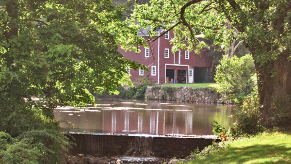
Heading toward Denville from the historic airstrip the road passes one of Northern New Jersey's most photographed and painted sites: the Dixon homestead, a cluster of houses and rustic red barns built during the 18th, 19th and 20th centuries and home to the Miller and Dixon families, who made their livelihoods in iron, ice, coal and farming over the years. In the 21st century, the homestead did a star turn as a set for the popular HBO television series, The Sopranos. For one of its episodes, in a spectacular stunt, the house closest to the road was filmed as if in flames (part of the mob plot), as curious onlookers craned for a view over barriers erected on Rockaway Valley Road. All within sight of the ever-present Tourne.
Part of the Morristown National Historic Park, the formal walled garden, 200-foot wisteria-covered pergola, mountain laurel allee and North American perennials garden was designed by local landscape architect Clarence Fowler.
The Millstone Scenic Byway includes eight historic districts along the D&R Canal, an oasis of preserved land, outdoor recreation areas in southern Somerset County
Dedicated to preserving the heritage and history of the railroads of New Jersey through the restoration, preservation, interpretation and operation of historic railroad equipment and artifacts, the museum is open Sundays, April thru October.
Even today, if you needed a natural hideout—a really good one—Jonathan’s Woods could work.
Paths of green, fields of gold!