Following Pohatcong Mountain, another of the many Appalachian ridges that run through Warren County, the Pohatcong Watershed lies parallel and between those of the Musconetcong River to the south and the Pequest to the north.
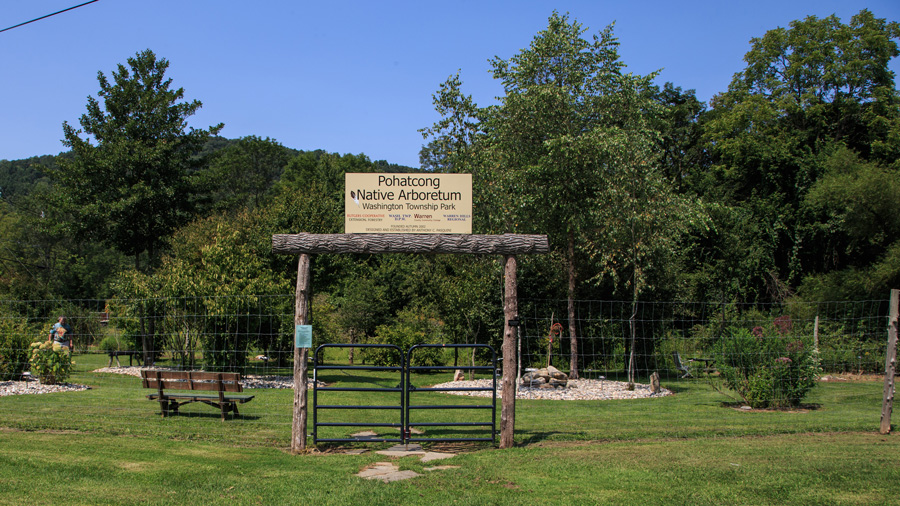
Just about halfway along its route down to the Delaware Valley, the Pohatcong Creek crosses State Route 31 between Oxford and Washington Borough. As it approaches Mine Hill Road, butting up to Oxford Mountain, the river enters Washington Township Park, part of the Pohatcong Creek Natural Area and home to the Pohatcong Native Arboretum, an ever-expanding collection of over 150 species of native trees and shrubs. The creek proceeds through the Bowerstown Historic District, site of former Plane 7 West and adjoining boat basin along the Morris Canal. An old canal aqueduct passes over the creek before it heads for the Washington Borough’s west side passing near the Karen Nash Memorial Butterfly Garden located at Memorial Elementary School at 300 West Stewart Street. The quarter-acre garden attracts not only butterflies, but also artists, photographers, and anyone else seeking a peaceful afternoon.
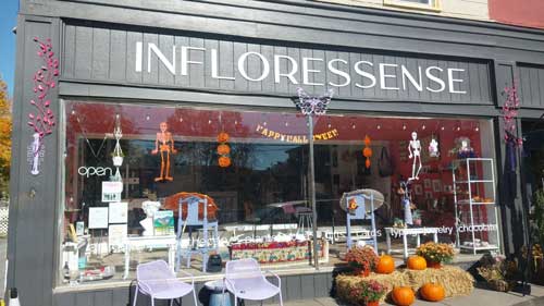
Washington Borough’s downtown district, under the direction of the Washington Business Improvement District (WBID), continues to flourish with an array of highly rated restaurants and cafes and a variety of shopping opportunities for the entire family. In addition, the downtown hosts a number of special events that include the Rock ‘n Roll Steampunk Fair in May, a Green Festival in June, and expansive street festival, Festival In The Borough, in September, featuring music, vendors and community-based live performances. From June to September you can get fresh, locally grown produce at the weekly farmers market on Fridays. The WBID is also very involved with the town’s gala 4th of July, Halloween and Holiday festivities.
The river crosses State Route 57 passing behind Warren County Community College, not far from The Blue Army Shrine of the Immaculate Heart of Mary at 674 Mountain View Road. The shrine is dedicated to the idea that enlightenment sometimes falls on ordinary people unexpectedly — in this case, in the form of St. Mary, the mother of Jesus, whose apparition appeared near the Portuguese town of Fatima. Devotees come from all over the world to visit the shrine and exact replica of the Chapel at Fatima.
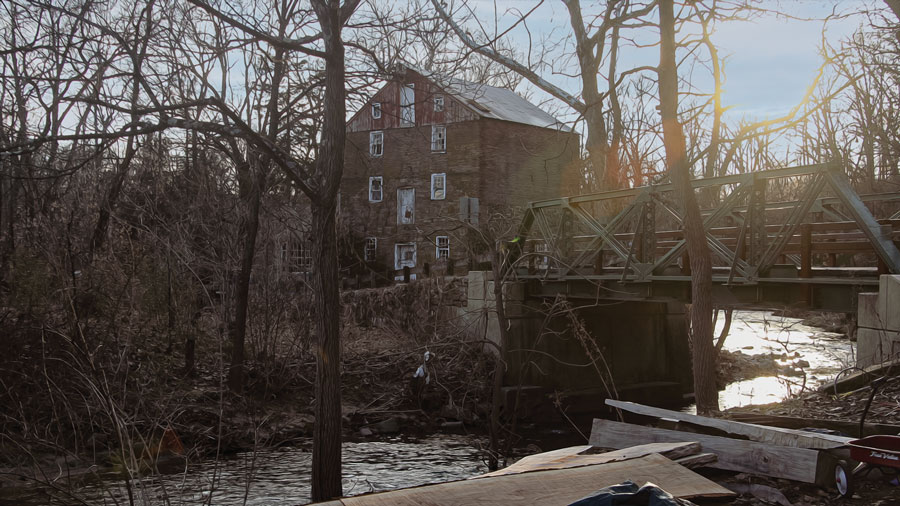
Enclosed by a line of trees, Pohatcong Creek moves through the hamlet of Broadway, then towards New Village, which in 1918 held a population of 250 people, had the trolley, railroad, post office, school, two churches, and telephone. Back behind the river Thomas Edison operated a cement mill employing six hundred men, mostly immigrants, the majority of whom commuted daily by trolley from Phillipsburg, Easton and Washington.
In another mile, the river turns south at Bread Lock Park and Warren County Historical Learning Center, which, at the site of the former Morris Canal Lock 7 West, contains a short section of cleared canal towpath and prism, a perimeter walking and nature trail, and extensive historical signage. The remains of the lock are still buried, but the lock tender’s house foundation, as well as a full-scale model of a canal boat, give visitors a glimpse into canal life. Inside the Learning Center, open on the second Sunday of each month, there are detailed models of the canal as well as other exhibits.
State Route 57, which follows a very old road alignment the valley of the Pohatcong Creek, a corridor of commerce and transportation from Washington to Phillipsburg for more than a century and a half, was authorized as a Turnpike as early as 1806, and has been designated a Warren Heritage Scenic Byway. As Edison built his concrete business, he constantly sought new ways to use his product. In 1912 an experimental section of highway was constructed with cement manufactured at his plant, perhaps the first paved road in rural America, and certainly the first concrete surface in New Jersey. Although Edison’s original concrete has since been replaced—the last of it finally pulled up in 2010—the segment proved quite sturdy, and concrete went on to play a major role in the construction of the U.S. Interstate Highway System. A historical marker documents the stretch of road, the Concrete Mile.

On the north side of the highway, Scotts Mountain hems in the valley. Known locally as Montana Mountain, named for the small hamlet that sits on its scenic plateau, the ridge is also host to the 650-acre Merrill Creek Reservoir, constructed to store water for release to the Delaware River during periods of low flow. The 2,300-acre property surrounding the reservoir holds a large network of trails worthy of exploration, including a 290-acre environmental preserve that offers boating and fishing, nature study, and hiking along the five-mile-long perimeter trail around the reservoir. The Visitors Center offers interactive kiosks, nature displays, historical exhibits, and a regular program of nature walks and workshops presented all year. Licensed boats at least twelve feet long with electric motors only are allowed as well as smaller kayaks and inflatables. Neither swimming nor camping is allowed, but the fishing is great with a huge population of lake, brown and rainbow trout, as well as large and small mouth bass. From the Scotts Mountain Hawk Watch observers can look out over the Delaware River valley to the north and west, and over the reservoir to the east and south. Birding is exceptional year-round especially during the fall hawk migration. In winter, various species of ducks gather in open, unfrozen sections of water, and many thousands of Canada geese and snow geese often congregate here. And the pair of nesting eagles that can easily be observed from a safe distance are consistently a star attraction, especially if you visit during a year when young eaglets complement the nest.
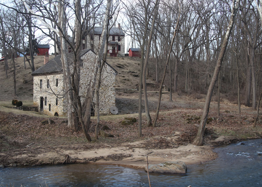
What is left of Merrill Creek trickles down the mountain under Route 57 and joins Pohatcong Creek south of Stewartsville, crossing under Interstate Route 78 and turning towards the section of Pohatcong Township known by its nineteenth century name, Springtown. Along the riverbanks stand nationally registered places that commemorate the township’s past. First, the Hixson-Skinner Mill Complex: the mill itself, head and tail race remnants, a miller’s house and garage, guest house, and a small pony pratt truss bridge across Pohatcong Creek. Then where the water ducks under County Route 519, the Springtown Stagecoach inn which has a long history that includes serving as an inn, blacksmith shop/forge, store, private residence, grange, municipal garage, and the Town Hall for the community of Pohatcong. There is a very strong local oral tradition that the inn served as an Underground Railroad safe house.
The stream follows Creek Road away from the highway towards its appointment with the Delaware through stunning countryside with the municipal Pohatcong Park along its south bank. To the northwest lie the Alpha/Pohatcong Grasslands, more than two thousand acres of farm fields, pastures, and grassland, half of which are preserved open space. On Oberly Road, beside a farm lane about a mile from Carpentersville Road, a small bench and plaque help mark a 128-acre tract that has been leased back to farmers, but is also known for excellent year-round birding.
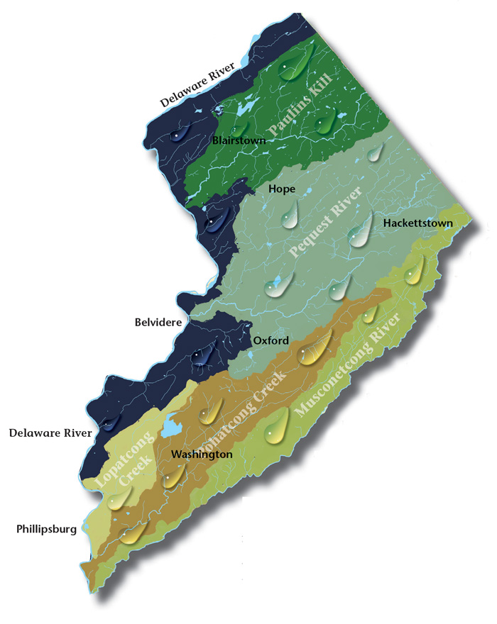
Paulins Kill Valley. The river flows north from its source near Newton in Sussex County, and then turns southwest toward the Warren County townships of Frelinghuysen, Hardwick, Blairstown, and Knowlton.
Pequest Watershed. The Pequest River begins in Sussex County and flows thirty-two miles to where it meets the Delaware in Belvidere, Warren’s county seat.
Lopatcong Creek. Lopatcong Creek pours down the Scotts Mountain Ridge in Harmony Township towards its appointment with the Delaware River twelve miles southwest at Phillipsburg.
Musconetcong Valley. Forming the southern Warren County border, the big river runs forty-two-and-a-half miles through a wide valley flanked on the northwest by the Allamuchy and Pohatcong mountains, and Schooley’s and Musconetcong mountains to the southeast in Morris and Hunterdon counties, twisting and turning over the ruins of our past.
The Centenary Stage Company produces professional equity theatre and also a wide variety of top-flight musical and dance events throughout the year.
Choose and Cut from 10,000 trees! Blue Spruce, Norway Spruce, White Pine, Scotch Pine Fraser Fir, Canaan fir, Douglas Fir. Family run on preserved farmland. Open Nov 29 - Dec 23, Tues-Sunday, 9-4. Easy Access from Routes 78 or 80.
Millbrook Village, part of the Delaware Water Gap National Recreation Area, is a re-created community of the 1800s where aspects of pioneer life are exhibited and occasionally demonstrated by skilled and dedicated docents throughout the village
A fine art gallery like no other! Unique, handmade gifts and cards as well as yoga, meditation, and continued learning lectures. Come in Saturdays for all-day open mic and Sundays to try unique nootropic chocolate or mushroom coffee. Browse the $5 books in the Believe Book Nook while you nibble and sip.
Local roots!