The Paulins Kill is New Jersey’s third-largest tributary of the Delaware River, and its watershed covers a total area of 177 square miles. The river flows north from its source near Newton in Sussex County, and then turns southwest toward the Warren County townships of Frelinghuysen, Hardwick, Blairstown, and Knowlton.
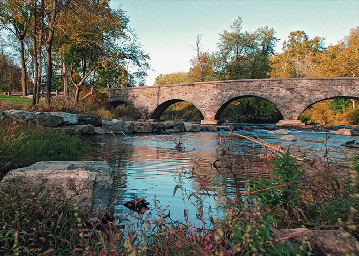
Warren County greets the Paulins Kill at a stone bridge about a mile southwest of the Shafer Grist Mill in Stillwater. Flowing another mile through bucolic pastures favored by horseback riders, the kill begins to skirt pristine White Lake, early christened for the color that sparkles up through its clear waters; the whiteness caused by shells which covered the entire bottom. The white mineral product, called marl, was once mined as a vital additive to cement.
There is car-top boat access to the pond and a well-maintained trail system through the surrounding 665-acre natural preserve with karst limestone exposures and sinkholes, lush meadows, and stands of mature hemlock and hardwood forests characteristic of the Kittatinny Valley and Ridge. The preserve is also home to several historical points of interest, including remnants of a stone marl processing and icehouse facility, a lime kiln, and the historic Vass Homestead. Several more hiking trails in the area are maintained by the Ridge and Valley Conservancy which protects and preserves natural areas that constitute the region’s rural character.
The spring-fed lake discharges from its south side to a stream that makes a brief trip downhill to the nearby Paulins Kill as it passes another historic grist mill just behind the hamlet of Marksboro, where the population has spiked in the recent decade, from eighty-two to eighty-six. There the water aligns closely with the twenty-seven-mile Paulinskill Valley Trail, part of the linear Kittatinny Valley State Park that begins in Sussex County and follows the abandoned railbed where the New York, Susquehanna and Western Railway laid tracks down the valley between the Kittatinny Mountain and the New Jersey Highlands all the way to the Delaware. With many access points along the way, the flat, cinder-based path is easy for walkers and perfect for horseback or mountain bikes. In addition to abundant wildlife, the attentive will notice a progression of artifacts from the rail era, from station foundations, mileage and whistle markers, cattle passes, battery boxes, railroad bridges, creameries and ice houses that serviced the lines in their heyday.
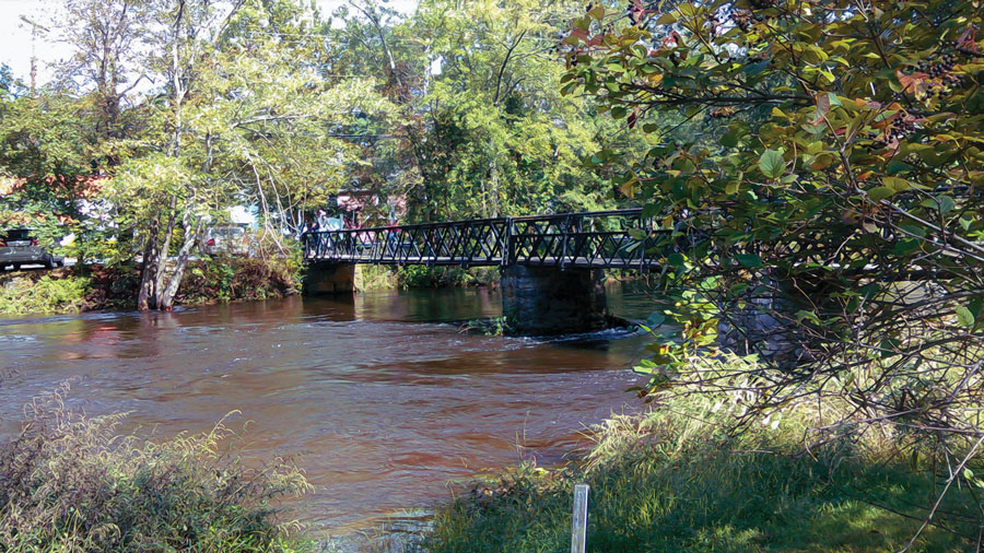
Past Marksboro the trail moves along the north bank of a dammed portion of the river known as Paulina Lake, the site of a former nineteenth-century community. Then in another mile down the trail, the river slides into Blairstown under a low-slung iron footbridge, currently in the early stages of nomination for the historic register by the Blairstown Historic Preservation Committee. Installed in 1893, this bridge replaced a wooden version that was built 1877 at the advent of the Blairstown Railway. The Committee has been busy pursuing its mission of conservancy, having established a series of interpretive plaques along a walking tour through the historic village which, in 1839, renamed itself in honor of its most celebrated citizen, then thirty-six-year-old John Insley Blair. Although he achieved national prominence as a railroad magnate, entrepreneur, and philanthropist over the course of nearly the entire nineteenth century, Blair always returned to his hometown, residing there in a relatively modest house until his death in 1899. Among his many local contributions was the prestigious preparatory school, Blair Academy (1848), also a designated Historic District comprised of twenty-two buildings on 550 acres along State Route 94 near Main Street.
Almost all of the primary buildings within Blairstown’s Historic District, including a prominent stone mill, were built during John Blair’s lifetime. The Victorian homes and two-story porches that remain on many of the storefronts on Main Street give this village along the Paulins Kill a distinctive historical flavor complemented by interesting specialty shops, galleries and a restored theater that has introduced an ambitious schedule of popular and jazz music. The town hosts an annual Fourth of July Celebration, a Fall Festival, and Jingle on Main for the holidays.
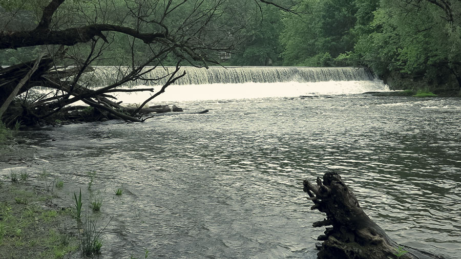
The kill escorts the trail west from Footbridge Park until they briefly diverge at Blairstown Airport which is open for public use, and where glider flights over the magnificent Kittatinny Ridge are also available. The rail trail rejoins the creek in Knowlton Township where they lead to a gigantic concrete bridge that spans the Paulins Kill at Hainesburg. The huge viaduct, one of two constructed in Knowlton on the Lackawanna Cut-Off rail line in 1909, remains fascinating. Actually, it requires only one of the bridge’s seven arches to cross the river, one spans the roadway, while still another opens to a section of trail from which you can gain perspective on the enormity of this monument as the abandoned line juts off into the distance towards the second viaduct over the Delaware. The Paulins Kill meanders on under yet another ancient stone bridge at Brugler Road, surrounded by forested hillsides and farms. On the downstream side of the bridge, large limestone boulders are scattered on the shores and in the water. An abandoned hydroelectric dam was recently removed, and the river’s natural flow restored. Previously obstructed by the dam, migratory shad have returned to the Paulins Kill for the first time in years.
The Paulins Kill meets the Delaware River at the village of Columbia where a nearby pedestrian bridge crosses the Delaware affording strollers a captivating view of the Water Gap, one of New Jersey’s most impressive and familiar natural features. The famous notch that dominates Warren County’s western skyline, where the river cut through a sandstone ridge, has long been a landmark for natural splendor and recreational attraction. South of the Paulins Kill, its watershed yields to tributaries that tumble directly into the Delaware River from the higher elevations that line the valley. One of these cascading mountain streams proved a prime location for a mill constructed by James and Adam Ramsay, who settled here in the late eighteenth century. The hamlet of Ramsaysburg, now a preserved historic site, thrived until the mid-1800s when John I. Blair established the village of Delaware as a terminus for the Warren Railroad. A hotel, store and train station turned the town into a commercial center that dominated the township, while bringing attention to its natural allure for vast numbers of vacationers. Today’s modern highways once again bring visitors to the rural scenic landscapes and pristine waters of the Ridge and Valley, where a rich history awaits exploration.
Blair Creek PreserveWest Fairview Lake Lane in Stillwater Township and on Sand Pond Road in Hardwick Township |
Although this almost-pristine woodland is home to rare, threatened, and endangered animals like the timber rattlesnake and red-shouldered hawk and plants such as Pink Lady-slipper, its location was the impetus for preservation. Blair Creek Preserve is part of a 12,000-acre uninterrupted block of forest with no roads, a pure stretch of trees unmatched in the state. |
Gnome Hollow PreserveStillwater Road, Frelinghuysen |
Hike through dense stands of native hardwoods, important habitat for migrating songbirds, owls and large mammals Several vernal pools are also found throughout the forest. |
Limestone Ridge Preserve23 Hope Rd (CR 521), Blairstown |
A trail loops through a forested tract of land immediately south of the Paulinskill, characterized by “pinnacle and trough topography underlain by Kittatinny Valley limestone. |
Spring Valley PreserveTown Hall parking lot, Hardwick |
Ferlas Pond Nature Trail features a large sinkhole pond that drains underground, and emerges on the surface as springs feeding another pond near Slabtown Creek, thus the name Spring Valley. |
Birch Ridge RavineBirch Ridge Road, Hardwick |
Hikers enjoy a deep ravine through which feeder tributaries tumble dramatically past mossy rock outcrops of shale and sandstone and a mature forest of hardwoods mixed with hemlocks and white pines. |
Dark Moon PreserveCounty Route 519 at the Warren/Sussex County line on Wintermute Rd. |
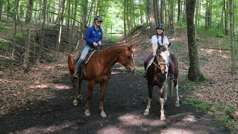
Walk or ride horseback through fields and forest with limestone rock exposures hosting rare plants, a pristine stream, and an important archaeological site which holds the remnants of a small Minisink settlement about 600 years old. |
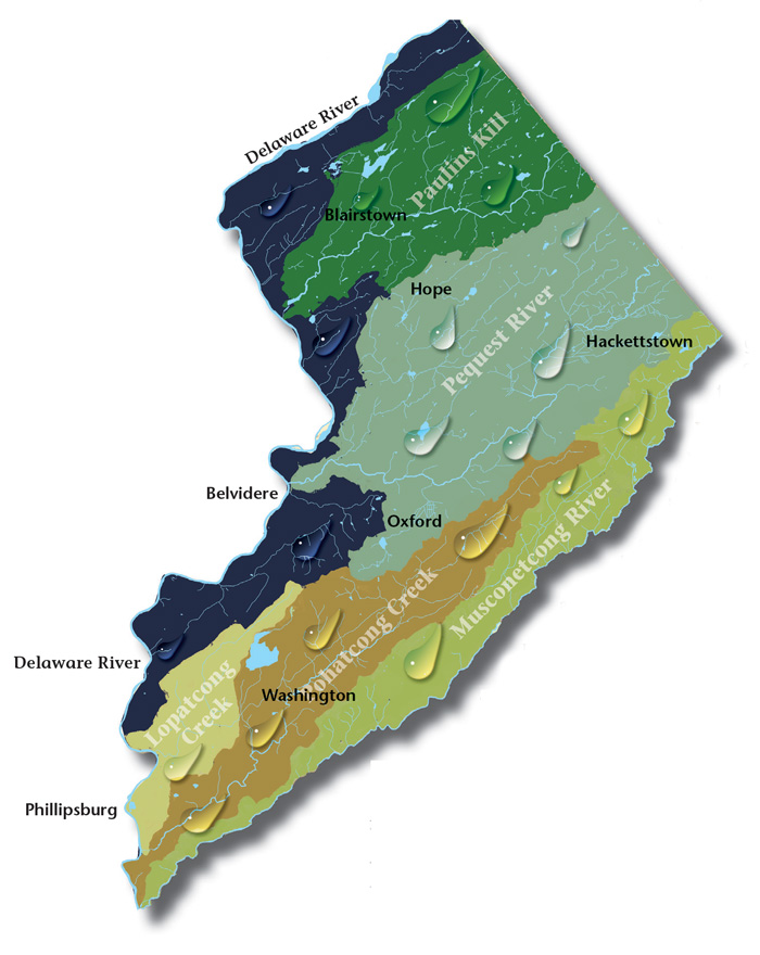
Pequest Watershed. The Pequest River begins in Sussex County and flows thirty-two miles to where it meets the Delaware in Belvidere, Warren’s county seat.
Lopatcong Creek. Lopatcong Creek pours down the Scotts Mountain Ridge in Harmony Township towards its appointment with the Delaware River twelve miles southwest at Phillipsburg.
Pohatcong Creek. Following Pohatcong Mountain, another of the many Appalachian ridges that run through Warren County, the Pohatcong Watershed lies parallel and between those of the Musconetcong River to the south and the Pequest to the north.
Musconetcong Valley. Forming the southern Warren County border, the big river runs forty-two-and-a-half miles through a wide valley flanked on the northwest by the Allamuchy and Pohatcong mountains, and Schooley’s and Musconetcong mountains to the southeast in Morris and Hunterdon counties, twisting and turning over the ruins of our past.
Millbrook Village, part of the Delaware Water Gap National Recreation Area, is a re-created community of the 1800s where aspects of pioneer life are exhibited and occasionally demonstrated by skilled and dedicated docents throughout the village
The 8,461 acre park includes the 2500-acre Deer Lake Park, Waterloo Village, mountain bike and horseback trails.
Local roots!
The Centenary Stage Company produces professional equity theatre and also a wide variety of top-flight musical and dance events throughout the year.
Choose and Cut from 10,000 trees! Blue Spruce, Norway Spruce, White Pine, Scotch Pine Fraser Fir, Canaan fir, Douglas Fir. Family run on preserved farmland. Open Nov 29 - Dec 23, Tues-Sunday, 9-4. Easy Access from Routes 78 or 80.