The Pequest River begins in Sussex County and flows thirty-two miles to where it meets the Delaware in Belvidere, Warren’s county seat. The Pequest starts just south of Newton and ends in Belvidere where it empties into the Delaware River. In Warren County, it passes near Allamuchy State Park, Jenny Jump State Forest, Pequest Wildlife Management Area, and the Beaver Brook Wildlife Management Area. The watershed includes a wealth of remnants from Warren County’s agricultural and industrial heritage.
A good place to begin exploring the contours of the Pequest Valley might be at the Johnsonburg Swamp and Dark Moon Preserves in Frelinghuysen Township, which have been set aside to encourage natural growth with minimal human encroachment. Johnsonburg Swamp Preserve boasts sinkholes, caves, natural springs, and Mud Pond, a wetland harboring rare plant species and endangered wildlife. Trails lead to cliff tops where, at High Rocks, hikers may stop and view Mud Pond far below. The limestone outcroppings overlooking the pond are the largest rock formations of their kind in New Jersey. If your raindrop falls here, just two miles from the banks of the Paulins Kill, it is destined for an entirely different experience. From the wetlands Bear Creek rises and flows south towards the Pequest through Johnsonburg, once known and named in1754 for the only jail in the Northwest New Jersey frontier: Logg Gaol.
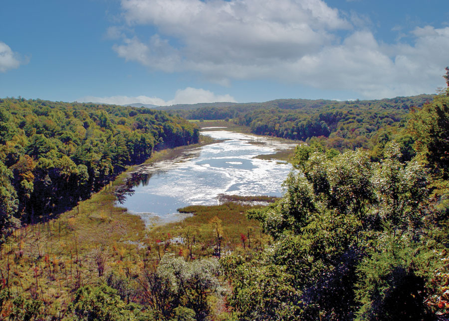
Jenny Jump Mountain pushes Bear Creek south where it catches up to the Pequest south of Interstate Route 80 in the Great Meadows. Thousands of years ago, after the last glacier, the place was at first a lake, and then a swamp that became a lake again after every rainfall or snowfall. A glacial moraine, a ridge of rock and dirt left by the melting glacier, dammed up the Pequest at present day Vienna and, after rainfalls, caused floods throughout Great Meadows and surrounding areas. Finally, in 1870, the river obstructions at Vienna were removed and the rest of the river through Great Meadows deepened along with parts of Bear Creek and Trout Brook. The remaining five thousand acres of farmland known for its rich muck soil (black dirt) remains agriculturally prosperous to this day. Besides producing hundreds of acres of sod, row upon row of greenhouses, a gardener’s Nirvana, are filled with annuals, perennials, mulch, herbs and farm fresh seasonal produce grown in the fertile meadows. Today the Pequest runs quietly through the meadows that border it and provides a calm but enjoyable trip in a canoe with little evidence of the civilization that envelops it.

Northwest of the meadows, beyond Shades of Death Road, lies Jenny Jump Mountain and 2,015 acres of state forest containing tent and trailer campsites, group campsites and shelters. There are nine miles of hiking trails through hardwood forest and rows of white pine planted decades ago by the Civilian Conservation Corps. Beginning near park headquarters, the Summit Trail reaches its peak at 1,090 feet, where it meets the Ghost Lake Trail that winds down the southeast side of the mountain back toward Great Meadows. Ghost Lake, also accessible from Shades of Death Road for car top boat launches, offers great bass fishing before it is overtaken by weeds each year. Two interesting small caves are a short distance from the parking lot. Another unique feature of Jenny Jump State Forest is the United Astronomy Club of New Jersey’s Greenwood Observatory, a roll-off roof structure housing a 16-inch Newtonian Telescope, a lecture room, a display room and a radio astronomy/ham-radio room. To the southwest, a second section of Jenny Jump borders Mountain Lake, another of the larger lakes within the Pequest watershed.
Viewpoints facing northwest from Jenny Jump’s ridge overlook the Moravian Village of Hope. One of America’s first planned communities, the village was settled by members of the Moravian religious sect, who arrived in 1769 and remained for almost forty years. They left a beautiful and durable legacy constructed from cut limestone graced with red brick or stone arches over windows and doorways, herringbone doors, and steeply pitched roofs. A walking tour of Hope, which was entered into the State and National Register of Historic Places in 1973, is a journey through living history, carefully maintained by the active and vigilant H.O.P.E (Help Our Preservation Effort).
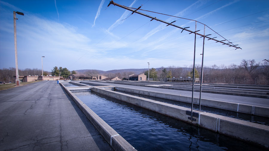
The Pequest leaves its easy gait as it starts its drive below Great Meadows towards the Delaware, rocky and shallow as it parallels State Route 46 along the north edge of the four-thousand-acre Pequest Wildlife Management Area. Below the surface is a large aquifer containing some of New Jersey’s purest water. A network of wells supply water to the Pequest Trout Hatchery, a Division of Fish and Wildlife facility that produces brook, brown, and rainbow trout for public waters every year. When state COVID guidance permits it to reopen, the Natural Resource Education Center will again provide programs about a wide range of natural resource topics for schools, groups and the general public. Visitors can enjoy a video about the trout rearing operation, a self-guided tour, exhibits, picnic areas and a marked trail network that features a self-guided interpretive natural resource trail. Needless to say, trout fishing in this part of the Pequest is extraordinary, and there are public and wheelchair-accessible access points.
The river and road continue through hills and fields that yield scant evidence of the former Pequest Iron Furnace. There are no markers or monuments to the bustling commerce once hosted there; the company offices, stock house, air pump houses and busy railroad interchanges that churned out massive quantities of iron product 130 years ago. But the abandoned railbeds cut through the hillside and rusty bridges over the river remind us of the abundant ores pulled from dozens of mines in the hills surrounding the river valley near what is now Buttzville.
That heritage is, however, commemorated at Oxford a few miles south on State Route 31. The area’s rich ore deposits made Oxford the longest continuous iron producer in the United States, from 1741 to 1965. By 1766, Dr. William Shippen Sr. was the sole owner of a 4,000-acre estate and furnace tract. The manor that he built oversaw tenant farms, a gristmill, sawmill and company store for the workers. Oxford Furnace saw a series of innovations in the iron industry, including various forms of heating the blast, steam power blowing, the use of coal for fuel, and in 1835, the first hot blast in America.
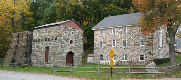
Shippen Manor overlooks Oxford and the iron era structures that remain from its dramatic perch on the brow of a hill above the village. Listed on the State and National Registers of Historic Places, the restored manor operates as a museum and venue for popular summertime lawn concerts. From Academy Street in Oxford, you can hike along an old wagon road heading uphill towards an overlook at West Oxford Mountain Natural Resource Area. Oxford’s Furnace Lake offers swimming and picnic facilities.
The Oxford Furnace stone structure, over two stories high, also has been preserved. The Methodist Church that stands only yards away from the Furnace was originally the grist mill. Among structures still standing in the area are the Company Store and Car Wheel Factory (both circa 1850), rows of workers’ homes, the mansions of the Scranton brothers, lime kilns, and a railroad tunnel, which starts in Oxford and heads under the hill toward Washington. A plaque commemorating the completion of the Van Nest Gap Tunnel in 1862 rests in the wall alongside Shippen Manor. That path the visitor walks along was once the roadbed of the Warren Railroad.
The Pequest continues west towards and the County Seat of Warren County, the Victorian town of Belvidere where it enters the Delaware River. As it approaches, the Pequest makes a sharp left turn, joined by the rushing Beaver Brook, which has its beginning in Hope and runs through the 435-acre Beaver Brook Wildlife Management Area. The Pequest, with Beaver Brook added, enters a deep chasm, then rises to road level again as it enters Belvidere. One of the first non-Indian settlers in this area was Major Robert Hoops who, when he came to the area just prior to the Revolutionary War, saw the value of the river’s power; it falls a full fifty feet in its last mile to the Delaware. Hoops dammed the river and had several mills and other water powered plants along it. He also operated a large slaughterhouse here during the Revolution here to supply Washington’s army. During part of the war Hoops served with General Washington as an aide.
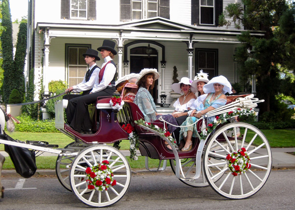
Designated as the county seat in 1825, Belvidere retained its role as a bustling commercial center through the nineteenth century, boasting two carriage manufacturing businesses and the busy Bel-Del Railroad. Today, the town’s serene and peaceful blend of Colonial and Victorian homes shaded by large elms, oaks, buttonwoods and pines make its heritage unmistakable, one that the town celebrates each September. At 114 Greenwich Street, the Country Gate Playhouse community theater offers a schedule of performances plus youth-oriented productions and workshops in a former movie theater built in 1939. At 313 Mansfield Street, the Warren County Historical Society Museum holds an eclectic collection of Warren County artifacts, antiques and furnishings, and a genealogical library housed in a circa 1848 brick townhouse.
Pequest Wildlife Management Area & Trout Hatchery605 Pequest Rd., Oxford 908/6374125 |
Three short blazed nature trails, two abandoned railbeds, and a trout hatchery paralleling the Pequest River. At the hatchery, a marked trail network features a self guided interpretive Natural Resource Trail. There are also several public fishing access points on the Pequest. More... |
West Oxford Mountain Natural Resource AreaAcademy Street, Oxford |
While the network of trails through the forested hillsides offer opportunities for hiking, biking, photography, and hunting, its most intriguing feature is its involvement in the history of the local iron industry, signified most prominently by the Oxford Furnace and Shippen Manor nearby. |
Roaring Rock ParkBrass Castle-Harmony Road (CR 647), Washington Township |
Named for the roar of rushing water from Brass Castle Creek, the network of trails offers varying amounts of difficulty and challenge for hikers, ranging from very easy to moderately difficult. A 1.9-mile perimeter trail encompasses the Dick Flint Natural Area. |
Lake Marguerite Wildlife RefugeJonestown Road (CR 625), Washington Twp. |
A well-maintained trail network of flat, easy trails passes through a diverse mix of ecosystems in the 22-acre refuge. |
Merrill Creek Environmental Preserve34 Merrill Creek Road, Washington |
Among several trails throughout the 290-acre preserve, the 5.5-mile Perimeter Trail follows old woods roads that surround the reservoir, providing scenic views and access to a variety of wildlife habitats. Along the northern shoreline, ospreys and eagles perch on dozens of bare, skeletal “drowned” trees, surveying the water for fish. More... |
Marble Hill Natural Resource AreaRiver Rd. (Rt. 621), Phillipsburg |
Located along the Delaware River, there are four miles of blazed hiking trails that offer seasonal vistas of the river valley. One trail leads to a former mine known as the “Ice Cave.” |
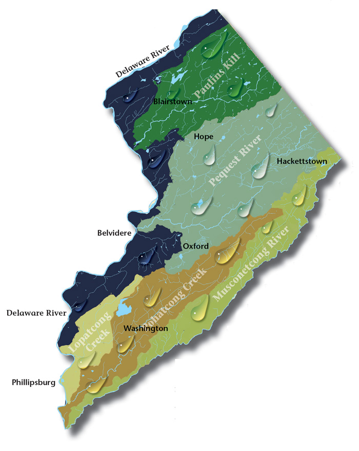
Paulins Kill Valley. The river flows north from its source near Newton in Sussex County, and then turns southwest toward the Warren County townships of Frelinghuysen, Hardwick, Blairstown, and Knowlton.
Lopatcong Creek. Lopatcong Creek pours down the Scotts Mountain Ridge in Harmony Township towards its appointment with the Delaware River twelve miles southwest at Phillipsburg.
Pohatcong Creek. Following Pohatcong Mountain, another of the many Appalachian ridges that run through Warren County, the Pohatcong Watershed lies parallel and between those of the Musconetcong River to the south and the Pequest to the north.
Musconetcong Valley. Forming the southern Warren County border, the big river runs forty-two-and-a-half miles through a wide valley flanked on the northwest by the Allamuchy and Pohatcong mountains, and Schooley’s and Musconetcong mountains to the southeast in Morris and Hunterdon counties, twisting and turning over the ruins of our past.
Millbrook Village, part of the Delaware Water Gap National Recreation Area, is a re-created community of the 1800s where aspects of pioneer life are exhibited and occasionally demonstrated by skilled and dedicated docents throughout the village
Consider Rutherfurd Hall as refuge and sanctuary in similar ways now, as it served a distinguished family a hundred years ago.
The 8,461 acre park includes the 2500-acre Deer Lake Park, Waterloo Village, mountain bike and horseback trails.
Local roots!
A fine art gallery like no other! Unique, handmade gifts and cards as well as yoga, meditation, and continued learning lectures. Come in Saturdays for all-day open mic and Sundays to try unique nootropic chocolate or mushroom coffee. Browse the $5 books in the Believe Book Nook while you nibble and sip.