Lake Hopatcong is central to the New Jersey Skylands, not only geographically, but also to the many levels and facets of the region's character. Its name derived from the language of the people who first inhabited these fertile grounds along the Minisink Trail, Hopatcong's waters reflect Northwest New Jersey's prolific history of transportation, industry and recreation. If you take a drive around the lake, or if you're fortunate enough to enjoy a boat or kayak ride on the water, we hope that, from this brief account of the lake's evolution, you'll understand a bit more about where you are.
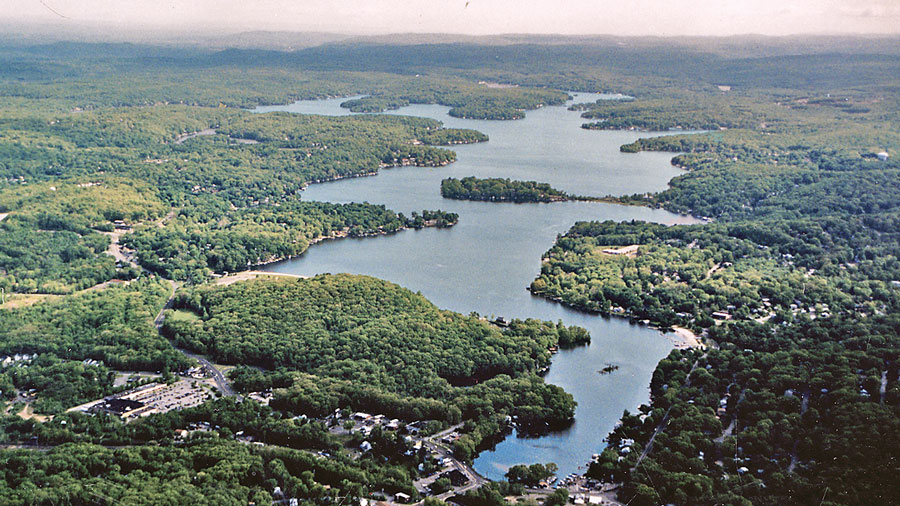
Lake Hopatcong's man made borders qualify it as New Jersey's largest lake, more than six miles long and covering 2,600 acres. Over a mile wide in some places, less than eight hundred feet in others, its irregular shape consists of numerous points and coves. A walk along its shoreline would cover at least thirty miles, passing by precipitous rocky cliffs, gently sloping hills, and flat beaches. Very shallow in some spots, fifty feet deep in others, a series of natural and human events has shaped the lake as we see it today.
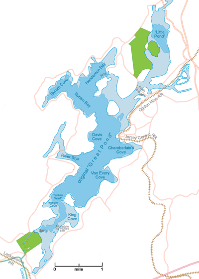
Prior to the last ice age, the waters of the prehistoric Hopatcong basin fed into the Raritan River. But the advancing glacier, which shaped much of the contour of the New Jersey highlands, formed a long terminal moraine before finally retreating, and left a natural dam that forced the basin's waters into the Musconetcong River. After the ice receded over 12,000 years ago, it left behind two individual glacial lakes of disparate size, nearly two miles apart, called "Great Pond" and "Little Pond" in past centuries.
In the early 1700s, the Great Pond stretched between Hopatcong State Park and Henderson Bay. Today's islands, which, back then, were just projections of the mainland, hosted aboriginal camps, villages, and fishing places, some now covered by the lake's waters. The area north of the Brady Bridge was a long, low grassy or wooded area. And Little (or Bleachley's) Pond was a small body of water just south of Woodport.
In his 1648 journal, one early explorer of northern New Jersey named a large inland body of water, possibly the Great Pond, the "Sandhay Sea"; the significance of the name is unknown. But John Reading, an early surveyor, used the lake's Indian name "Huppakong" in his 1715 journal and stayed in a "whigwam" there the following year. A clue to the name's meaning might come from an old legend claiming that there once existed a quarter-mile-long "causeway", probably a natural formation that connected the area that would become Bertrand Island to the Sussex County shore a quarter-mile to the west. Although there is disagreement today as to the authenticity of this claim, an 1853 map of Lake Hopatcong labels that area of the lake as "Indian Warf". According to George Copway, a mid-1800s Ojibwa Native American advocate, "Hopatcong" means "stone water," or "stone over water", an appropriate description of a land bridge. One thing is for certain: the name does not mean "honey waters of many coves", as fanciful early travel writers claimed.
Around 1764, a dam built for the Brookland forge and mill at the southern end of the "Great Pond" raised the ancient lake's water level by about six feet, possibly cutting off some of the original lake's projecting points to form islands. The village of Brookland, later corrupted to "Brooklyn", grew around the site, which is now within Hopatcong State Park. A millstone from the Brookland mill is on display there.
Although mid-1700s legislators and documents referred to the lake as the "Great Pond", the lake was often referred to locally as "Brookland Pond". And on a 1769 map it was labeled "Musconetcong Pond". Despite that, from the 1770s onward, most mapmakers continued to label the lake with the ancient Indian name "Hopatcong" as it continues to be used today.
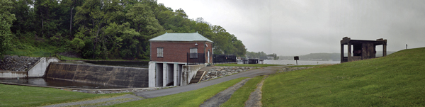
Even as George Macculloch fished upon the waters of the Great Pond in the early 1800s, envisioning how a cross-state canal would benefit local iron companies, he realized that a major source of water would be necessary to keep the canal system filled. Lake Hopatcong, situated at the highest point of the canal system, would help to serve that purpose. By 1831 or so the new Morris Canal Company had purchased the Brookland forge site, replacing the first dam with one of its own, into which a lock and canal feeder channel had been incorporated. As the water began to rise, eventually twelve feet above the natural level of the Great Pond, Lake Hopatcong's current form took shape.
The greatest changes occurred at the northern end of the lake's basin, as the land between the Great and Little Ponds began to flood. As Raccoon and Halsey Islands were cut off from the mainland, the water continued up a narrow depression to form Prospect Point, cutting it off from the land north of Nolan's Point. The rising water separated Liffy Island from the mainland, and incorporated Little Pond into the larger impoundment we know today. At the southern half of the lake, the inundation flowed back around Pickerel Point to form the River Styx, while closer to the dam, King Cove formed and Bertrand Island (then called Canfield Island) was cut off from the mainland. Another low area south of the dam flooded to form the narrow shallow cove, which ends at Landing.
In the 1850s the Morris & Essex Railroad (later named the DL&W or Lackawanna), was the first railroad to advance to Lake Hopatcong, but did not consider the area to be important enough to build a station there. Instead, fishermen and adventurers had to disembark at the Drakesville (Ledgewood) station and endure a stagecoach ride to the Lake over three miles of rough roads.
In 1866, the new Ogden Mine Railroad began to transport iron and zinc ore from the mines near Ogdensburg to an ore transfer terminal along the lake's shore at Nolan's Point. After the ore was loaded into canal boats, steam tugs towed them down to the Morris Canal feeder at the dam. Mules then pulled the canal boats down the feeder and into the main canal for delivery to foundries to the east and west. This same year, high-grade iron ore discovered in Minnesota's Mesabi Range would eventually spell disaster for the iron mining industry in the hills of northern New Jersey.
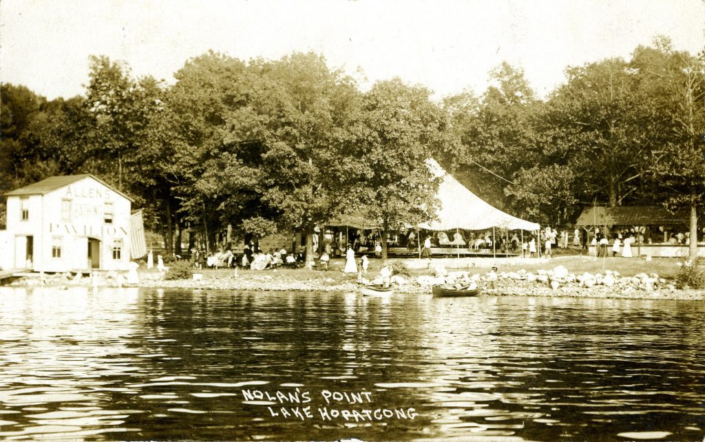
The expanding railroad network ultimately bypassed the Canal entirely, but found new fortune at Lake Hopatcong. In 1882, the Central Railroad opened the lake's first passenger station at Nolan's Point and began running excursion trains the following year; a day's picnic away from the city, surrounded by a beautiful natural setting. Amusements were constructed, more people came, and the tourist boom had begun, helping the Central to offset the declining mining business.
Happy visitors wanted to stay longer than the Central's one-day excursions, yet there were only a few small hotels along Hopatcong's shore. To satisfy demand, dozens of hotels and rooming houses opened for business by the turn of the century. Nolan's Point, where canal and railroad employees once toiled, became a destination for relaxation and recreation. During the 1890s, the Jersey Central carried 50,000 persons to the lake each summer! By 1886, more than thirty years after first laying tracks past Landing, the DL&W Railroad finally built a passenger station there on the lake's southern tip, and, despite its late start, by the 1930s the Lackawanna enjoyed being the predominant tourist railway to the Lake.
While the railroads helped put the Morris Canal out of business, the budding tourist trade precipitated the growth of a new industry on the lake. Disembarking passengers boarded steamboats to be carried to their final destinations. Central Railroad passengers were picked up at Nolan's Point; Lackawanna passengers at Landing. About 1886, the same well-heeled financial group that owned the Lackawanna Railroad and the Morris Canal, founded "Lake Hopatcong Steamboat Company", commonly known as the Black Line. Although a swampy half-mile-long cove extended down the lake nearly to Landing, it was too shallow for steamboat navigation. To remedy the situation, the Black Line was granted access to the feeder canal, the only deep water connecting the new Landing railroad station to the main lake.


In 1890, when the local entrepreneur, Theodore F. King, founded the Hopatcong Steamboat Company, also known as the "White Line", the canal company refused to grant King access to the canal feeder, and therefore the rail passengers at Landing. Instead, King employed small boats to ferry customers from Landing station to his steamboats in the lake's deeper water. Since his rates were cheaper, passengers did not mind the inconvenience, perhaps even preferring his service. When the canal company countered by lowering the lake, making it impossible for even a small boat to pass through the swampy cove, King again responded, this time by dredging a channel through the shallows, deep enough for his White Line steamboats to come within a short walk of the Landing station. Both lines continued to serve travelers, connecting them with trains of either railroad, or simply providing a cruise. Passengers would hoist either a white or black flag above their dock, designating their choice for transport.
Among the few smaller boat lines was the Blue Line, with only a couple of boats that offered only local travel on the Lake. And the Raccoon Island Ferry, still in service today, began carrying passengers in 1932 as a replacement for a damaged bridge that was never rebuilt.
By 1910, the Morris County Traction Company had completed a trolley line to Lake Hopatcong. Although it took much longer to reach the lake than by the train, the trolley fare was far more affordable for the common family. In an effort to attract more tourists, the trolley company offered "moonlight excursions" that included a boat ride. But its greatest impact was the attraction it created on a beach at the end of its line: the amusements that would become Bertrand Island Park.
Ten years later the trolley company had carried more than seven million passengers, but, by the late 1920s, the trolley was gone, replaced by a bus line that took over its former route. By that time Bertrand Island had grown into a prominent amusement park, rivaling Nolan's Point, and erecting the lake's famous first roller coaster. Although Nolan's Point had suffered a devastating fire in 1908, by the mid-1920s it, too, had grown to offer tourists a carousel, roller coaster and other arcade rides, a shooting gallery, restaurant, and more. But improved roads and vehicles spurred the decline of the Nolan's Point amusement park until it closed in the early 1930s. Bertrand Island, more easily accessed by car and bus, thrived for a few more decades until it also closed in the 1980s.
The railroads also brought a thriving ice harvesting business to the lake from the 1880s to the mid-1930s, in the days of iceboxes, before modern refrigeration. Hundreds of ice cutters harvested the thick ice, storing it in half a dozen large ice houses along the shore until being shipped to metropolitan areas. Oddly, from time to time, these ice houses burned to the ground. Rebuilding after a fire in 1912, the Mountain Ice Company, another Theodore King enterprise, constructed the largest ice house in the country, a fireproof structure using steel and hollow ceramic tiles.
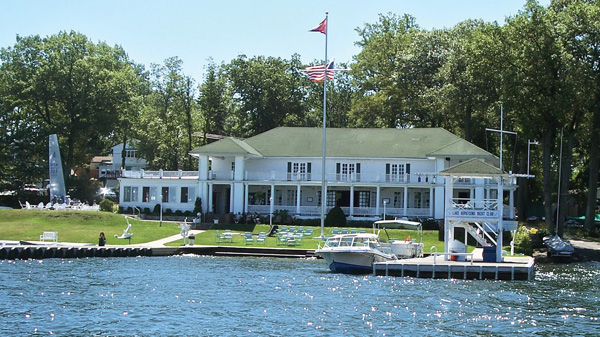
After such an illustrious tradition as a vacationing destination, you wouldn't expect that not a single overnight accommodation remains on the shores of Lake Hopatcong. Even day-access to the water is sometimes challenging: although the lake itself is publicly owned, the vast majority of its shoreline is private. The beach and picnic areas at the State Park, which now look out over the water to condos along Bertrand Island rather than the famous roller coaster, fill up quickly during the summer. For boaters, the only other public access is at Lee's Marina, a Morris County Park facility on Great Cove along Espanong Road in Mt. Arlington. And, although there is no shortage of marinas and dock space, boat rentals are hard to find. Still, the fishing is fantastic. And there are restaurants that allow a seat by the water or on a deck overlooking the "jewel of the mountains." Then, of course, there's always a friend. Or a friend of a friend who has a boat…
Marty Kane is a busy professional; a government attorney and administrator at Picatinny Arsenal. But when I left a midweek message inquiring about an upcoming presentation called "Made In Lake Hopatcong" at the Lake Hopatcong Historical Society number I found online, he returned the call almost immediately.
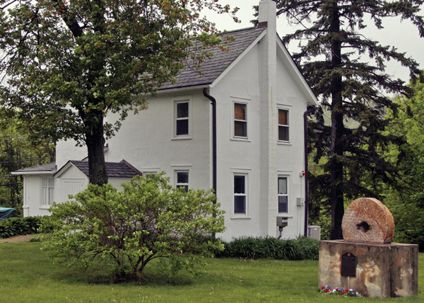
Affairs of the lake have been an important part of Marty Kane's life for a long time. He grew up on the lower eastside of Manhattan, but each summer his father would drop him, his mother and brothers and sisters off at a bungalow colony in River Styx on the western shore of Lake Hopatcong. "We'd stay until Labor Day," remembers Kane. "My dad would come out on weekends. We didn't even have a car out here. My mother didn't get a driver's license until she was forty. I had my summer life and my regular life." The Kane's eventually bought a Chris-Craft and a little bungalow on Lakeside Boulevard, which remained in the family until about seven years ago, but Marty didn't become a "year-round" person until he took the job at Picatinny in 1979. In 1990, his fond memories drew him to the Lake Hopatcong Historical Society and the organization's museum, where he has since focused much of his energy helping to develop historical presentations and exhibits. On the grounds of Hopatcong State Park, the Lake Hopatcong Historical Museum occupies the c.1825 house once inhabited by the Morris Canal lock tenders who controlled the feeder lock and entrance into the canal from the lake. Kane has also incorporated much of the information and photography from the museum's collection into two books: "Lake Hopatcong Then & Now" and "Lake Hopatcong - A Century of Memories".
The Museum is a good one, with thousands of photographs and artifacts representing the lake's illustrious past, all carefully researched and extensively documented. Permanent exhibits at the Museum depict pre-Colonial Lenape settlements, the Morris Canal period, "Simpler Times", the great hotel era, famous residents, and Bertrand Island Amusement Park. The museum also houses collections pertaining to dozens of topics and celebrities associated with the lake: Bette Cooper, Lotta Crabtree, Joe Cook, Hudson Maxim, and many more.
"There is nostalgia, but it doesn't mean that the best days of the lake aren't ahead of us," says Kane, who is also part of a larger community effort, as a trustee member of the recently formed Lake Hopatcong Foundation. "The lake has too many parents—four towns in two counties—it's really an orphan. Nobody takes complete ownership." The Foundation was engineered, and to this point, largely funded, by Béla Szigethy, another lifelong devotee of the lake. Modeled after the Central Park Conservancy, the organization has a simple mission: "to improve Lake Hopatcong for the enjoyment of everyone, now and in the years to come." The methods to accomplish that include environmental vigilance, enhanced recreational opportunities, and improved quality of life for residents. Among the many initiatives that the Foundation has already supported is the new Prospect Trail System, where a wide manicured path already leads through a wooded area from just north of the Brady Bridge over to Liffy Island. Hikers will eventually cross over a bog to the undeveloped island and a pristine shoreline.
Because of heavy seasonal traffic at the State Park, the Lake Hopatcong Museum has limited hours during the summer and resumes regular hours in October. Until then, you can refer to the museum's engaging website.
Follow the tiny but mighty Wallkill River on its 88.3-mile journey north through eastern Sussex County into New York State.
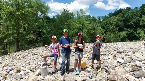
“The Fluorescent Mineral Capitol of the World" Fluorescent, local & worldwide minerals, fossils, artifacts, two-level mine replica.
Peters Valley shares the experience of the American Craft Movement with interactive learning through a series of workshops. A shop and gallery showcases the contemporary craft of residents and other talented artists at the Crafts Center... ceramics, glass, jewelry, wood and more in a beautiful natural setting. Open year round.
Dedicated to preserving the heritage and history of the railroads of New Jersey through the restoration, preservation, interpretation and operation of historic railroad equipment and artifacts, the museum is open Sundays, April thru October.