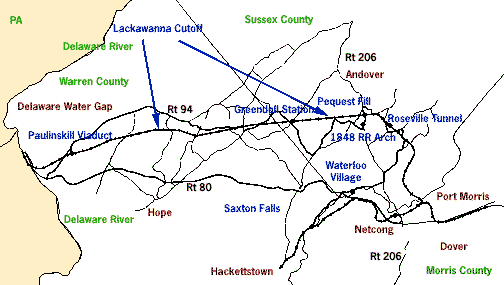
Considered by many to be the most scenic rail line in New Jersey, the Lackawanna Cut-Off was the last mainline to be built in the state (it was opened in 1911). Indeed, if the Lackawanna hadn't waited, it would not have possessed the technology necessary to build the line in the first place. Starting at Port Morris, the Cut-Off travels west through scenic Morris, Sussex and Warren counties on its way to the Delaware Water Gap, across some of the world's largest rail embankments, and two massive concrete viaducts. Looking for what is uniquely New Jersey? Following this route takes you along one of the most innovative endeavors of the early part of this century and through some of the prettiest countryside in the northeast!

Built in 1903 by the Lackawanna Railroad, Netcong station was originally called Netcong-Stanhope. Until the 1960s, two mainlines straddled either side of this classic brick structure. The boxcar-cum-storage shed is positioned near the location of the old freight house. Both Netcong and Port Morris were hot with rail activity. Today, N.J. Transit uses the former Lackawanna mainline to provide service to Hackettstown. Turn right out of the lot, crossing the tracks, and then immediately turn left onto Rt. 46 East. At the circle, take Rt. 206 south and follow signs for I-80 West. Travel west on I-80 to Exit 4, Columbia, and take Rt. 94 North. Drive 2.1 miles, passing underneath the Cut-Off, to Station Rd. on the right. Take Station Rd. approximately one half mile to Paulinskill Viaduct.

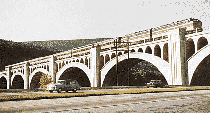
The Lackawanna Railroad pioneered in the use of reinforced concrete. At the time of its completion in 1911, Paulinskill Viaduct (also known as Hainesburg Viaduct) held the record as the world's largest railroad reinforced concrete viaduct. As you gaze up at the massive structure, it's easy to understand why. Walk in past the first arch to view the idyllic Paulinskill River.
Turn the car around to head back to Rt. 94 North. After you pass the intersection with Rt. 521 on the right, look for the right turn onto Kerrs Corner Rd. and follow it, crossing Marksboro-Hope Rd. You'll pass Shot-in-the-Dark Dairy Farm and you'll go through the intersection of Mott Rd./Mill Rd. to arrive at the tee intersection (unmarked) with County Rd. 661 South. Turn right, cross under the Cut-Off, and follow 661 just .3 miles to turn left on County Rd. 519 North (Dark Moon Rd.). Watch for the Cut-Off paralleling the road you are on.
On your right you'll pass a stone octagonal house. The Octagon style was most popular in the 1850s and 1860s and found its way into barns and houses alike. Although promoted under the guise of practicality, legend has it that the Octagon style eliminated the corners so that, "the devil could not hide in them."
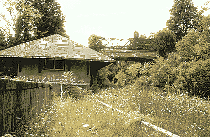
One mile from your last turn, you'll pass under the Cut-Off and at 2.1 miles, Rt. 519 will veer to the left. Stay straight; at this point the road becomes Hibler Rd. Follow Hibler for a half mile and turn right on Henry Rd. Drive approximately one mile to the intersection with County Rd. 611 North. Turn left, and slowly drive past the Greendell Deli General Store, and take the right just past the store into the Greendell station area. Follow the gravel drive north to the station.

Go back to the intersection of Henry Rd. and Rt. 611, bear left and take 611 South (Kennedy Rd.) for 2.4 miles to the tee intersection with County Rd. 517. Turn left, take 517 North to the flashing light, and bear left onto County Rd. 603 North. In a mile and a half, cross over the right- of-way of the former Lehigh and Hudson River Railway. You'll have to look hard to see it, as the weeds are fast reclaiming this rail route to New England. Continue on 603 for another half mile, but don't pass under the Cut-Off.
Ahead of you looms the start of the Pequest Fill, the world's largest railroad fill. It's over three miles long and 110 feet off the valley floor at its maximum height. Under the fill to your left is buried the original Huntsville school house. During the Cut-Off's construction, the railroad chose to purchase the structure and build the town another one farther away rather than changing the alignment of the rail line. As the construction progressed, the old school house was buried under tons of rock, to the sound of cheering school children who watched from a distant hillside.

At Rt. 206, turn left and proceed north one mile to the traffic light in Andover. You'll pass under the Cut-Off again. The Cut-Off was nicknamed the "Highline"; its superior elevation above the surrounding terrain makes it unsurpassed in the state's inventory of potential scenic excursion lines.
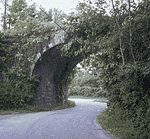
Turn right at the light onto County Rd. 517 North (Main St.). At the stop sign, proceed straight onto County Rd. 613 North. Take 613 just .4 miles to the tee intersection, turning right onto Roseville Rd.; travel 3.9 miles until you reach the intersection with County Rd. 607. In this leg, you'll cross the Cut-Off three times on one overpass and two underpasses.
Roseville Tunnel lies just south of the overpass, and if you waited until late autumn to take your trip, you might catch a glimpse of the north portal to your left. The excavated stone was used in the fill south of the tunnel, visible after you cross beneath the Cut-Off for the final time. At the intersection of County Rd. 607, turn right and drive two miles to Rt. 206. Lake Lackawanna will be on your left. You'll also pass Wild West City on your left. At the light at Rt. 206, turn left, and drive a half mile south to the next light.
At this point in your journey, you can continue south on Rt. 206 to return to Netcong, or turn right onto County Rd. 604 West and continue 2.3 miles to Waterloo Village (temporarily closed.)
The Village of Waterloo is a restored 19th century village whose rise, decline, and rebirth is closely linked to the evolution of transportation. Waterloo is home to the Canal Society of New Jersey's Canal Museum, which has a most impressive canal exhibit. Photo opportunities abound here and at Saxton Falls (2.9 miles further west on County Rd. 604), where the reflection of the Morris Canal or Saxton Lake is sure to enhance any foliage photograph.