Tucked in along New Jersey's Kittatinny Ridge between the better known parks of High Point State Park to the north and the Delaware Water Gap National Recreation Area to the south, Stokes has neither the most spectacular gap nor the highest mountain in the state. The Forest does have its own charm and quiet presence that you and your family won't want to miss.
A good starting point is the Forest Headquarters off of US 206 a few miles north of Culvers Lake. Free maps and a guide to the forest are available at the office or online. The guide is great fun for kids as it has drawings they can color on their own. You can also learn current regulations covering fires and of any areas that might be closed. There are three camping areas in Stokes State Forest. Some sites may be reserved in advance.
The Forest covers 15,482 acres of the ridge and valley province in northern New Jersey. The ridge is made of Shawangunk conglomerates that are more resistant to erosion than the shales and limestone formations in the Flatbrook and Kittatinny Valleys. The rocky ridges and soil, not advantageous for farming, were harvested extensively for timber. Most of the virgin stands were gone by the mid 1800's. In 1907, the state bought 5,000 acres to add to 500 acres given to the people of New Jersey by Governor Edward C Stokes. The protected forest continued to grow through the years, most recently adding 2,900 acres through the use of Green Acres Program funds.
Leaving the park office go down Coursen Road to Kittle Field. This day use area is great for families with young kids. There is an open field and a play ground for running about and burning energy built up during a car ride.
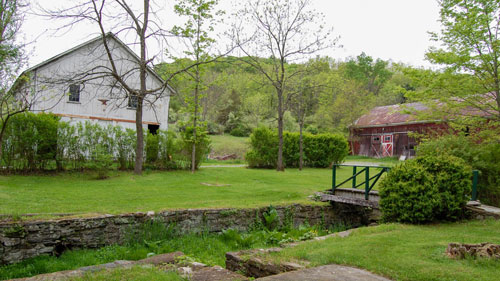
The picnic area was built by the Civilian Conservation Corp (CCC) in the late 1930s. The pavilion is characteristic of CCC construction: built with large beams and a stone fireplace it is basic, simple, and lasting. Some of the barbecues were also built back in the thirties. They have four pits and a central chimney.
From the picnic area a trail marked by metal tags goes along an old woods road to the site of Snoot's first sawmill. Seven generations of Snoot's worked in the lumber industry along the banks of Stony Brook. This trail is a good walk for a family with small children. The woods road is wide and easy to follow. You need to watch for the spot where the trail leave the woods road. Follow the metal tags to find the remains of the pond dam. Some stones are still stacked by the stream marking the site of the mill dam. This rock wall, built without mortar, has stood since the early 1800s.
It's fun to imagine what the site must have looked liked back then. There is a sketch in the park guide that shows an artist's vision of the mill. Downstream from the dam are two rows of stones that mark the foundation of the sawmill. Trees now grow from what was once the inside of a building.
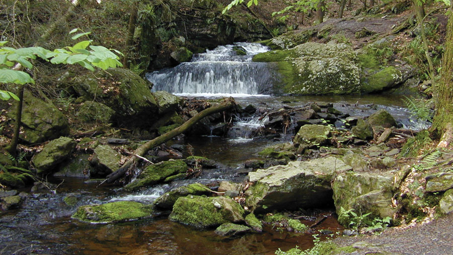
Go back to the woods road and continue to follow it. The Silver Mine Trail comes in on the right. The woods road follows Stony Brook. A ravine is on your left with small cascades. In about half a mile, you will come upon the remains of another mill pond.
Older children will love Tillman Ravine. The trails are steeper and a little rougher than the one at Kittle Field. Tillman Ravine is located in the southwest corner of Stokes State Forest. Use the Forest map to find your way along the forest's back roads to find the upper parking area.
Here, also, are a picnic area and plenty of trails to follow. Tillman Brook starts on the western slope of Kittatinny Ridge and flows down to the Flatbrook. The water flows across High Falls formation of green and red sandstone which create the ravine. The trails follow the stream down steep slopes blanketed with hemlocks and moss covered rocks. A long series of falls and cascades create a wild and scenic view. Many people visit the ravine in summer since it remains cooler here under the hemlocks than other areas of the forest. Early spring is also a great time to visit. You may have the entire place to yourself.
The Appalachian Trail cuts through the eastern edge of Stokes State Forest. for more than 12 miles. The A.T. runs 2000 miles from Georgia to Maine, and our local section provides a delicious adventure for older children and adults. Even a day hike along it connects you to this great American adventure. Starting in June, you will find "Through Hikers" along the trail, those that are trying to walk the entire trail in one year. Many others just hike short sections and keep track of what they have completed.
A good section for beginners is from the Route 206 parking area to Sunrise Mountain. This will give you a taste of the difficulty you might find along the trail without getting in over your head.
If you arrange to have two cars, you can leave one at Sunrise Mountain. Drive back to Rt. 206 and start your hike there. This way you will cover about 5 miles and can either hike back to your starting point (total of 11 miles) or drive back if your group is tired.
The Appalachian Trail in blazed with white rectangles. Follow the blazes north from the parking lot. The trail runs level for a short while, crosses the road to Sunrise Mountain and then it goes up steeply. After the steep section, there is a view towards the southeast which is a perfect place to rest. The A.T. continues gradually up till you reach the firetower. The total elevation change from the parking lot is about 500 feet. From here you follow the ridge gaining and losing a little elevation at a time. Don't forget to pack extra water and lunch. When you reach the pavilion on Sunrise Mountain, you will feel like you have really climbed a mountain. The view is great!

These hikes in Stokes State Forest give a taste of the areas to explore in this remote part of New Jersey's Great Northwest. Spring is the perfect time to visit Stokes, while the traffic is low. Later in the summer and fall, parking lots approach capacity and camping space gets scarce. Plan on visiting more than once; there are plenty of trails to explore, stopping by these woods for the paths not taken.
For more information call the Stokes State Forest office at (973) 948-3820 or check the NJ Division Parks & Forestry page.
“The Fluorescent Mineral Capitol of the World" Fluorescent, local & worldwide minerals, fossils, artifacts, two-level mine replica.
Peters Valley shares the experience of the American Craft Movement with interactive learning through a series of workshops. A shop and gallery showcases the contemporary craft of residents and other talented artists at the Crafts Center... ceramics, glass, jewelry, wood and more in a beautiful natural setting. Open year round.
Follow the tiny but mighty Wallkill River on its 88.3-mile journey north through eastern Sussex County into New York State.
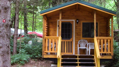
Located in Sussex County near the Kittatinny Mountains the camping resort offers park model, cabin and luxury tent rentals as well as trailer or tent campsites with water, electric and cable TV hookups on 200 scenic acres.