Outdoors and Nature Activities

More Outdoors

Stay in the Loop!

Get our newsletter, This Week in the NJ Skylands, with updates, special offers and good ideas!

Read current newsletter

Privacy Statement

Legstretchers

Sourlands Mountain Preserve, Ridge Trail

Story and photos by Mary Jasch

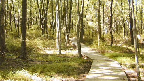
At the Sourlands Mountain Preserve on East Mountain Road in Hillsborough, three trails begin at the same Trail Head across the grass from the parking lot. Grab a map in the kiosk and enter the woods for this pleasant hike in Somerset County. Take the four-mile Ridge Trail, designated with a rectangular blaze. The blazes here are carved wooden plaques in geometric shapes. Walks are always easy at the trailhead, and this one starts with a smooth gravel/dirt path under tall trees.

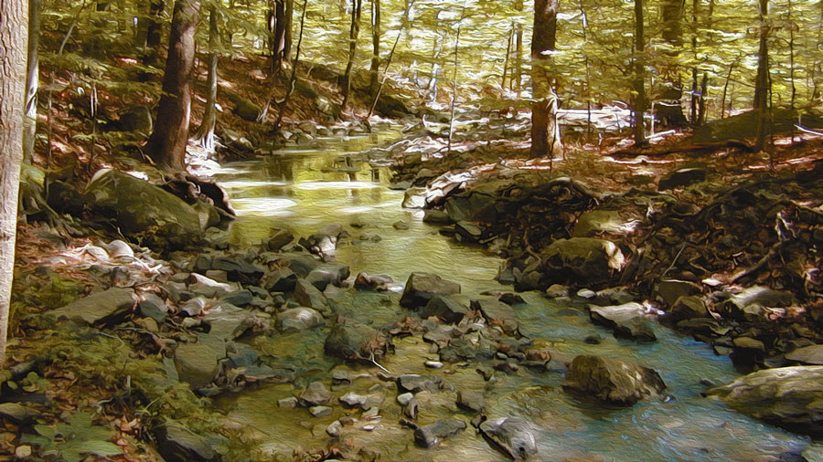
The Ridge Trail is a gentle climb for about a mile with winding walks on flat terraces interspersed between rises. The sunny path is wide through ferns, berries and spicebush, and a boardwalk covers an outwash of weathered and crumbled rock. There are no big boulders to rest on this trail until almost at the top. A rocky-bottom brook begins shallow and flows to a deep-cut streambed. Tall skinny beech, oaks and tulip poplars comprise a mixed oak forest here and cover the flattish hilltop and slopes.

The trail crosses the Texas Eastern Pipeline, offering an open, sunny habitat with abundant wildflowers and tall patches of Phragmites. For a great view on a clear day, follow the pipeline uphill, have lunch, then come back down to the rectangular blazed trail that re-enters the woods.

The path eases down the hill through grassy, open woods where thick Virginia creeper vines hang from the trees. The Boy Scouts built a handrail to assist hikers on the trail's steepest descent. At the bottom of the handrail, a wide flat boulder---conveniently located---is a great place to stop, rest, and have a snack. Further down, the Roaring Brook flows with a comforting sound, even in dry times. It eventually empties into the Millstone. On the final stretch, the trail crosses a gentle slope through towering deciduous trees that have shaded out a broad patch of old Eastern red cedars.

Sourland Mountain is a 10-mile long volcanic ridge of diabase--one of six in the Central Jersey lowland. Large boulders here were crushed for railroad beds, roofing shingles, and road surfaces. Its diverse landscape provides habitats for a variety of wildlife and plants. Rare plants found here include wild comfrey, winged monkey flower and ginseng. Threatened and endangered wildlife seen here include the grasshopper sparrow and barred owl.

Over 30,000 people a year, including birders, hikers and families out for a fun day, visit the Preserve. The Sourlands mark the southern boundary of many northern bird species, and the northern boundary of southern species such as the black-capped and Carolina chickadees. Birders know it and come here all the time. Bring binoculars and a bird field guide. There's an active pond near the parking lot and grassy picnic areas.

On the 2,600-acre preserve, there are three trails, two about a half-mile each. The Ridge Trail is a pleasant moderate walk through bright sunlit woods on wide paths. Mountain bikes and horses are allowed in season. Two hundred seventy three acres of the mountain extend into Hunterdon County and is under the jurisdiction of the Department of Parks and Recreation.

There are two trails for public use ­ a wide, flat service road that goes through deciduous woods, a marsh and a boulder field of diabase or "trap rock." The marsh is a perched wetland, a depression in impermeable rock, and filled by surface water. The South Loop Trail branches off the service road, becoming very wet and even crosses a stream. Be prepared to boulder-hop. The reward is a plethora of native wildflowers. Vernal pools provide great amphibian watching. See if you can find spotted salamanders, wood frogs, and gray tree frogs.

To get there: Rt. 206 to Amwell Road in Hillsborough. Turn left onto East Mountain Road. The parking lot is 0.6 mile south. Or, take Rt. 601 to East Mountain Road. For more information, contact Somerset County Park Commission at 908-722-1200 or mail to PO Box 5327, North Branch, NJ 08876. In Hunterdon, call Department of Parks and Recreation at 908-788-1158, or write to PO Box 2900, Flemington, NJ 08822-2900.

Comments

Richard Mitnick
28 Aug 2010, 21:58
O.K., not a site, a theory I have had for years:

If one examines a map with the townships names showing,
one sees a geographic flow from Green Township (Sussex County) through Independence and Liberty townships down into White Township (the last three in Warren County). Admittedly Allamuchy and Oxford Townships interrupt the flow, but they do not disturb its following of the ridge and valley topography in the valley east of the Jenny Jump ridgeline.

GREEN, INDEPENDENCE, LIBERTY, WHITE. New Hampshire's state colors are green and white. New Hampshire was a center of pre-Revolutionary War anti-colonial, anti-British sedition, the home of "Live Free or Die".

The above named New Jersey townships are also replete with roads such as "Freedom-Union Rd".

My theory is that this section of New Jersey was in sympathy with the good folk of New Hampshire, some of whom may have migrated to New Jersey.

This is a period of time with relatively primitive transportation, and families with offspring remaining near by, farming in the same areas for decades.

So, what do you think? I got on a genealogy email distribution list and, e.g., while supposedly independence Township was given its current name in 1921, I found the name attested to long before 1900.

Interesting?
Jim
28 Aug 2010, 18:39
Thank you very much Richard - I will stop by the store and pick up the book. I'm an amateur historian and folklore buff so the info is very helpful. If you know of any other spots of interest please share - actually invested in some new boots for the hike, but will be an excursion to check out the rock unless it's on private property.

Thanks again!
Richard Mitnick
28 Aug 2010, 18:14
O.K. Zion Road, East Amwell Twsp., not actually anywhere near the Sourland Mountain Preserve. Fortunately, I am a cyclist as well as a hiker, so I know the spot well.

There are two access roads. NJ Rte 518 from Rocky Hill west to right turn on Lindbergh, up Lindbergh to the top of the ridge, Zion Road will be on the right.

Or, Rte 514 west from New Brunswick, past Neshanic church, continue to Long Hill Road, left on Long hill, which after a while will become Zion Rd.

You are really going to need to know what this rock looks like, because , and I have a picture of it, it's not that big a deal.

It is in a book, "New Jersey's Sourland Mountain, by T.J. Luce. I got the book at Peacocks General Store, corner of Wertzville Rd and Linbergh Rd., don't know the actual town, the mailing address is Ringoes, and they are not in Ringoes. Check a Hunterdon county map for the store.

Really, unless you have a specific need, this rock is no big deal of a rock, at least above ground. The book says it shows "The process of fracture between two great slabs of diabase...creating a pillowing effect".

Be careful of cyclists.
Jim
28 Aug 2010, 17:27
Where is Knitting Betty's Rock?
Tuomas
24 Jul 2010, 20:20
The trail head is in the wrong place in the map on this page. The actual place is more to the south. Zoom in and you see two small ponds on the west side of the E Mountain Rd on the map. You can also see the parking lot in the satellite image.
david
10 Jun 2010, 08:38
can anyone help me. We are looking to rent for a private hilly terrain for a four day event. all we need is water access and a 150ft hill. dinnerads@gmail.com
Richard Mitnick
20 Apr 2010, 11:32
Ray-

At the parking lot, there is a kiosk with maps and a glass fronted display.
There is an updated trail map behind the glass. The maps in the boixes do not have the new - and wonderful - connector trail. But I am not sure it tells the whole story. bring a m,ap, or take a map, and draw in the new routes.

But- if you hike the Ridge Trail, 1-13, which means counter-clockwise, you will see that the old "6" is closed. You will go through the fence and see the new "6". You have been hiking the white squares blazes. Stick with them after the fence. DO NOT follow the red square blazes.

It sounds like what you did was follow the red squares up the ridge. They do end back at the pipeline.

After the fence, the red squares will go to the right. You want to go toward the left to continue your counter-clockwise hike.

You do not want to give up on this place. I go there a lot. I love it. Today, my friend and I went up to Ramapo Mountain State Park off Rte 287. Excellent. Well, so is Sourland: excellent.
Ray
20 Apr 2010, 10:53
I wish they'd update the trail brochures... I got lost when I got onto the 3M land and ended up circling back to the pipeline, when I had intended to head down along Roaring Brook. Oh well, an excuse to go back again sometime.
Richard Mitnick
07 Feb 2010, 03:09
Philip- Just go there, The Sourland Mountain Preserve, East Mountain Rd (off of 514), Hillsborough.

Get a trail map from the box, and if you can, take the Ridge Trail (white squares). If you are a serious hiker, you will be in heaven.
philip
06 Feb 2010, 23:13
i still dont understand any of these trails and i think they have the rivers mess up or something
Richard Mitnick
10 Sep 2009, 05:31
The two new trails noted by John above have now been blazed with red blazes. The red square trail connects back to the main Ridge Trail [white squares]. The red circular blazed trail runs north and ends at the gas line.
John
26 Jul 2009, 13:52
There's been a great addition to the park. Two new paths cross into land owned by 3M to add a nice addition so you can get back to "Roaring Brook". It goes from marker 6 to 8. The new trails can be found at the kiosk at the park entrance.
Steven L. Sacks-Wilner
30 Jul 2007, 13:33
nice article.
Needs one correction: Sourland Preserve in Hunterdon http://www.co.hunterdon.nj.us/depts/parks/guides/Sourland.htm is miles away and has no connection except it is a part of the same 90 Sq mile Sourland Mountain area http://sourland.org/planning/nri.pdf .

You need to submit your comment only once. Please be patient, sometimes our scripts behaves slowly.

*Name:
Email:
Notify me about new comments on this page
Hide my email
*Text:
 
Powered by Scriptsmill Comments Script
Site Contents and Contact Information
Questions and Comments
Advertising and Promotions
-- http://www.njskylands.com -- Revised: January, 2010--
Copyright ©1996-2010 Guest Services, Inc.